Adhering to constraints#
This notebook explains our approach to smallness regularization, with the goal of adhering to prior knowledge of topography we’re aiming to recover. In the scenario of a sediment-basement contact inversion, if we know the basement depth at a few points from drill holes or seismic data, we want the inverted results to adhere to these points, which we refer to as constraints.
Again, we will use the same synthetic data from the past two user guides, but add a little long wavelength noise to it to help show the effectiveness of our regularization.
Import packages#
[1]:
from __future__ import annotations

%load_ext autoreload
%autoreload 2
import logging

import pandas as pd
import verde as vd
import xarray as xr
from polartoolkit import maps
from polartoolkit import utils as polar_utils

from invert4geom import (
    inversion,
    plotting,
    regional,
    synthetic,
    utils,
)

# set up logging to see what's going on
logging.basicConfig(level=logging.INFO)
Create observed gravity data#
To run the inversion, we need to have observed gravity data. In this simple example, we will first create a synthetic topography, which represents the true Earth topography which we hope to recover during the inverison. From this topography, we will create a layer of vertical right-rectangular prisms, which allows us to calculated the gravity effect of the topography. This will act as our observed gravity data.
Sample the starting topography at 10 random locations and regrid with those sampled values. This simulates only knowing the depth to this topography at 10 boreholes.
[2]:
# set grid parameters
spacing = 500
region = (0, 40000, 0, 30000)

(
    true_topography,
    _,
    _,
    _,
) = synthetic.load_synthetic_model(
    spacing=spacing,
    region=region,
    # topography_coarsen_factor=2,
    # topography_percent_noise=0.02,
)

# create lower synthetic topography data
lower_topography = synthetic.synthetic_topography_regional(
    spacing,
    region,
    scale=1,
    yoffset=-1000,
)
[3]:
# the density contrast is between rock (~2670 kg/m3) and air (~1 kg/m3)
true_density_contrast = 2670 - 1
# prisms are created between the mean topography value and the height of the topography
true_zref = true_topography.values.mean()
# prisms above zref have positive density contrast and prisms below zref have negative
# density contrast
density_grid = xr.where(
true_topography >= true_zref,
true_density_contrast,
-true_density_contrast,
)
# create layer of prisms
prisms = utils.grids_to_prisms(
true_topography,
true_zref,
density=density_grid,
)
# the density contrast is between lower crust (~3100 kg/m3) and rock (~2670 kg/m3)
density_contrast = 3100 - 2670
zref = lower_topography.values.mean()
density_grid = xr.where(lower_topography >= zref, density_contrast, -density_contrast)
lower_prisms = utils.grids_to_prisms(
lower_topography,
zref,
density=density_grid,
)
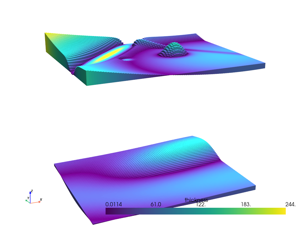
plotting.show_prism_layers(
[prisms, lower_prisms],
color_by="thickness",
log_scale=False,
zscale=20,
backend="static",
)
MESA: error: ZINK: failed to choose pdev
glx: failed to create drisw screen
[4]:
# make pandas dataframe of locations to calculate gravity
# this represents the station locations of a gravity survey
# create lists of coordinates
coords = vd.grid_coordinates(
    region=region,
    spacing=spacing,
    pixel_register=False,
    extra_coords=1001,  # survey elevation
)

# grid the coordinates
observations = vd.make_xarray_grid(
    (coords[0], coords[1]),
    data=coords[2],
    data_names="upward",
    dims=("northing", "easting"),
).upward

grav_df = vd.grid_to_table(observations)

grav_df["upper_surface_grav"] = prisms.prism_layer.gravity(
    coordinates=(
        grav_df.easting,
        grav_df.northing,
        grav_df.upward,
    ),
    field="g_z",
    progressbar=True,
)

# forward gravity of lower surface prisms
grav_df["lower_surface_grav"] = lower_prisms.prism_layer.gravity(
    coordinates=(
        grav_df.easting,
        grav_df.northing,
        grav_df.upward,
    ),
    field="g_z",
    progressbar=True,
)

grav_df["gravity_anomaly"] = grav_df.upper_surface_grav + grav_df.lower_surface_grav
grav_df
[4]:
| northing | easting | upward | upper_surface_grav | lower_surface_grav | gravity_anomaly | |
|---|---|---|---|---|---|---|
| 0 | 0.0 | 0.0 | 1001.0 | 6.966073 | -0.045074 | 6.920999 |
| 1 | 0.0 | 500.0 | 1001.0 | 8.535965 | -0.049696 | 8.486269 |
| 2 | 0.0 | 1000.0 | 1001.0 | 8.802495 | -0.055773 | 8.746722 |
| 3 | 0.0 | 1500.0 | 1001.0 | 8.723351 | -0.063154 | 8.660197 |
| 4 | 0.0 | 2000.0 | 1001.0 | 8.519803 | -0.071496 | 8.448307 |
| ... | ... | ... | ... | ... | ... | ... |
| 4936 | 30000.0 | 38000.0 | 1001.0 | 2.832952 | 0.558197 | 3.391148 |
| 4937 | 30000.0 | 38500.0 | 1001.0 | 2.816434 | 0.529278 | 3.345712 |
| 4938 | 30000.0 | 39000.0 | 1001.0 | 2.765486 | 0.491156 | 3.256643 |
| 4939 | 30000.0 | 39500.0 | 1001.0 | 2.607967 | 0.442645 | 3.050612 |
| 4940 | 30000.0 | 40000.0 | 1001.0 | 2.060362 | 0.384991 | 2.445353 |
4941 rows × 6 columns
[5]:
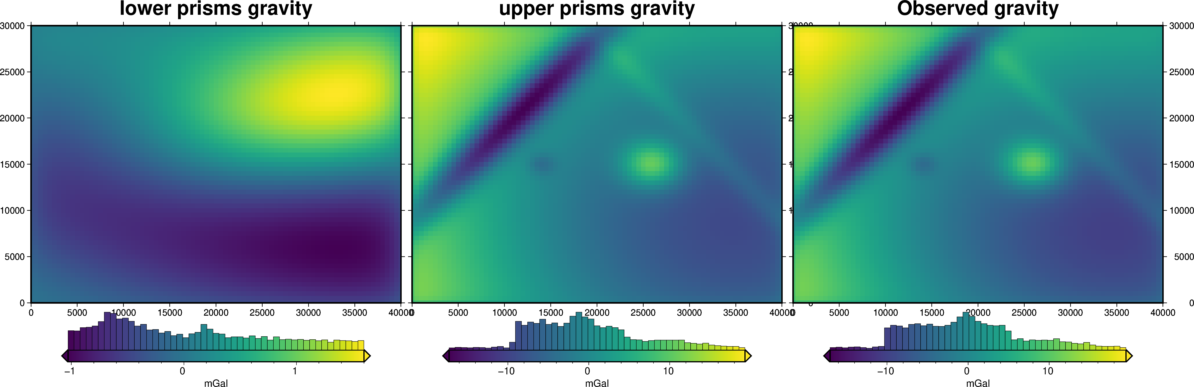
grav_grid = grav_df.set_index(["northing", "easting"]).to_xarray()

fig = maps.plot_grd(
    grav_grid.lower_surface_grav,
    fig_height=10,
    title="lower prisms gravity",
    cmap="viridis",
    hist=True,
    cbar_label="mGal",
    frame=["nSWe", "xaf10000", "yaf10000"],
)

fig = maps.plot_grd(
    grav_grid.upper_surface_grav,
    fig=fig,
    origin_shift="x",
    fig_height=10,
    title="upper prisms gravity",
    cmap="viridis",
    hist=True,
    cbar_label="mGal",
    frame=["nSwE", "xaf10000", "yaf10000"],
)

fig = maps.plot_grd(
    grav_grid.gravity_anomaly,
    fig=fig,
    origin_shift="x",
    fig_height=10,
    title="Observed gravity",
    cmap="viridis",
    hist=True,
    cbar_label="mGal",
    frame=["nSwE", "xaf10000", "yaf10000"],
)

fig.show()
Create “a-priori” topography measurements#
[6]:
# create 25 random point within the outcropping basement region
num_constraints = 25
coords = vd.scatter_points(
    region=vd.pad_region(region, -spacing),
    size=num_constraints,
    random_state=0,
)
constraint_points = pd.DataFrame(data={"easting": coords[0], "northing": coords[1]})

# sample true topography at these points
constraint_points = utils.sample_grids(
    constraint_points,
    true_topography,
    "upward",
)
constraint_points.head()
[6]:
| easting | northing | upward | |
|---|---|---|---|
| 0 | 21903.726653 | 19057.709618 | 472.843511 |
| 1 | 28392.385289 | 4657.245335 | 417.654600 |
| 2 | 24007.771667 | 27895.398594 | 537.989827 |
| 3 | 21750.444137 | 15633.601331 | 485.088965 |
| 4 | 17022.537174 | 12525.196260 | 471.304408 |
Create starting model#
[7]:
# grid the sampled values using verde
starting_topography_kwargs = dict(
method="splines",
region=region,
spacing=spacing,
constraints_df=constraint_points,
# dampings=np.logspace(-40, 0, 100),
dampings=None,
)
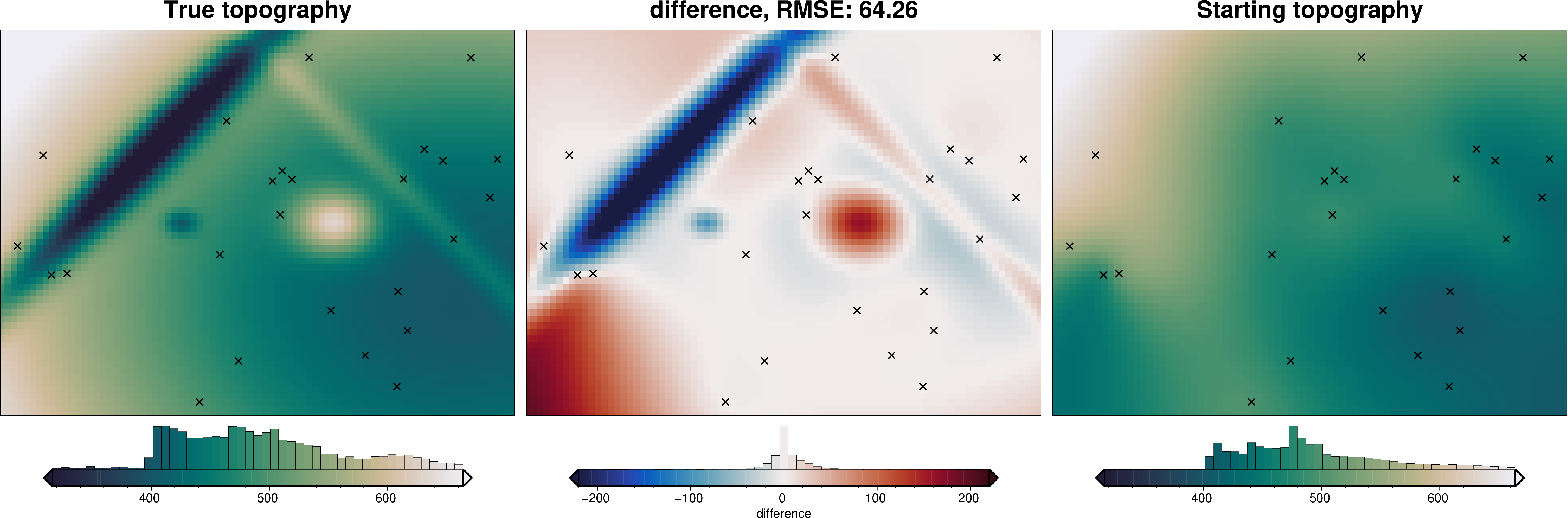
starting_topography = utils.create_topography(**starting_topography_kwargs)
_ = polar_utils.grd_compare(
true_topography,
starting_topography,
region=region,
plot=True,
grid1_name="True topography",
grid2_name="Starting topography",
robust=True,
hist=True,
inset=False,
verbose="q",
title="difference",
grounding_line=False,
reverse_cpt=True,
cmap="rain",
points=constraint_points,
points_style="x.3c",
)
[8]:
# sample the inverted topography at the constraint points
constraint_points = utils.sample_grids(
    constraint_points,
    starting_topography,
    "starting_topography",
)

rmse_starting = utils.rmse(
    constraint_points.upward - constraint_points.starting_topography
)
max_error_starting = vd.maxabs(
    constraint_points.upward - constraint_points.starting_topography
)

print(f"RMSE at constraints: {round(rmse_starting, 1)} m")
print(f"max error at constraints: {round(max_error_starting, 1)} m")
RMSE at constraints: 0.1 m
max error at constraints: 0.5 m
[9]:
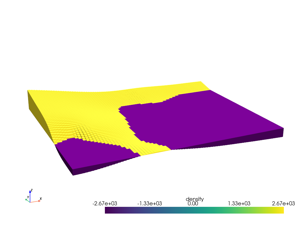
# prisms above zref have positive density contrast and prisms below zref have negative
# density contrast
density_grid = xr.where(
    starting_topography >= true_zref, true_density_contrast, -true_density_contrast
)

# create layer of prisms
starting_prisms = utils.grids_to_prisms(
    starting_topography,
    true_zref,
    density=density_grid,
)
plotting.show_prism_layers(
    starting_prisms,
    color_by="density",
    log_scale=False,
    zscale=20,
    backend="static",
)
MESA: error: ZINK: failed to choose pdev
glx: failed to create drisw screen
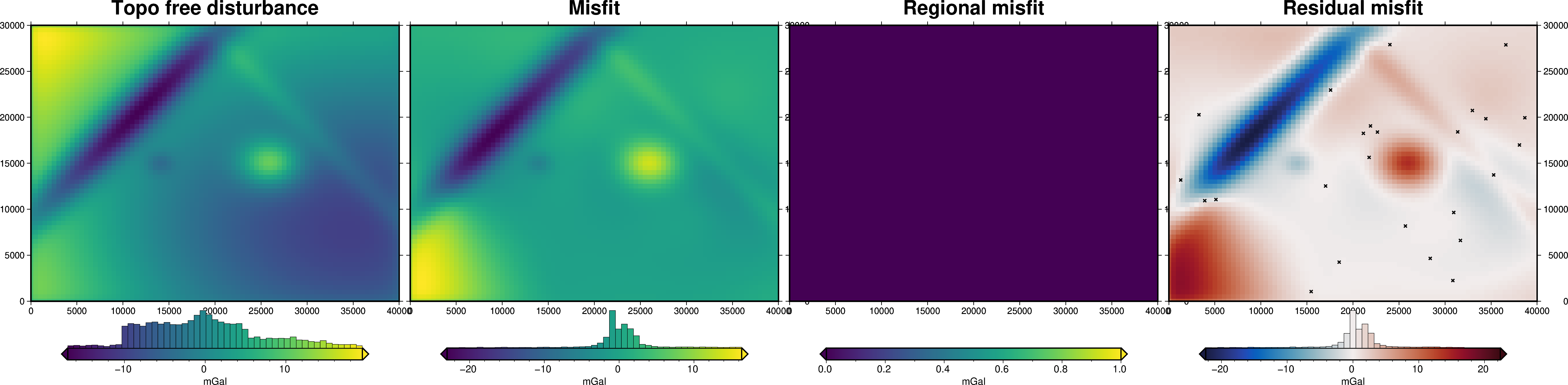
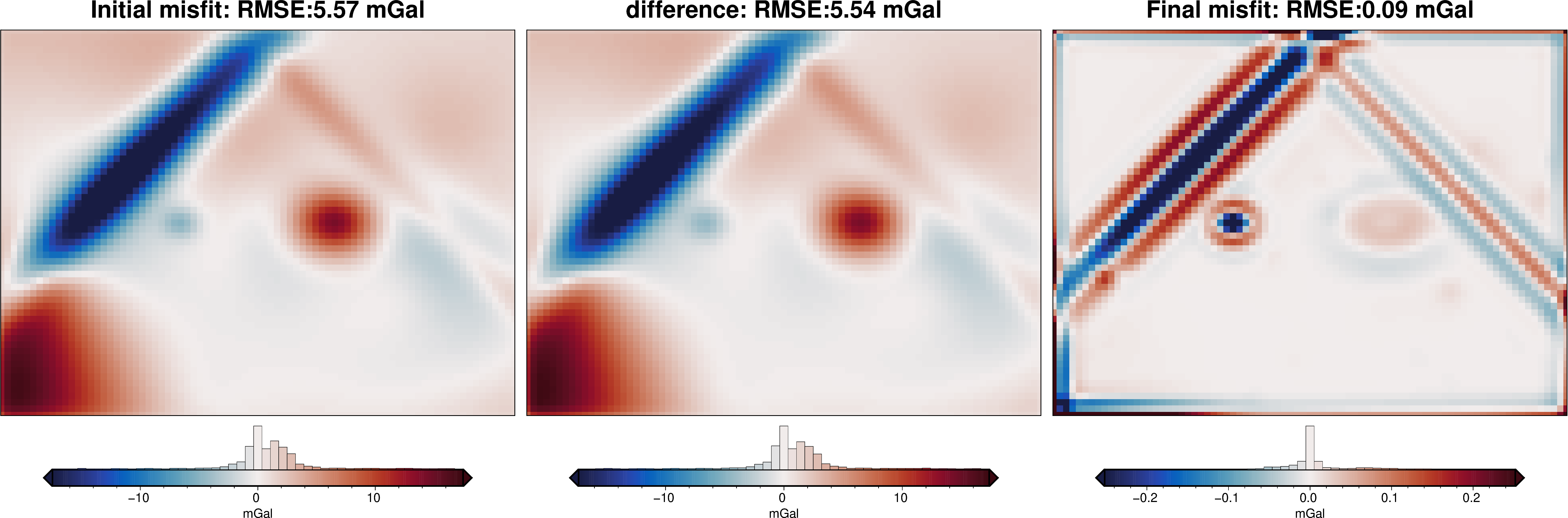
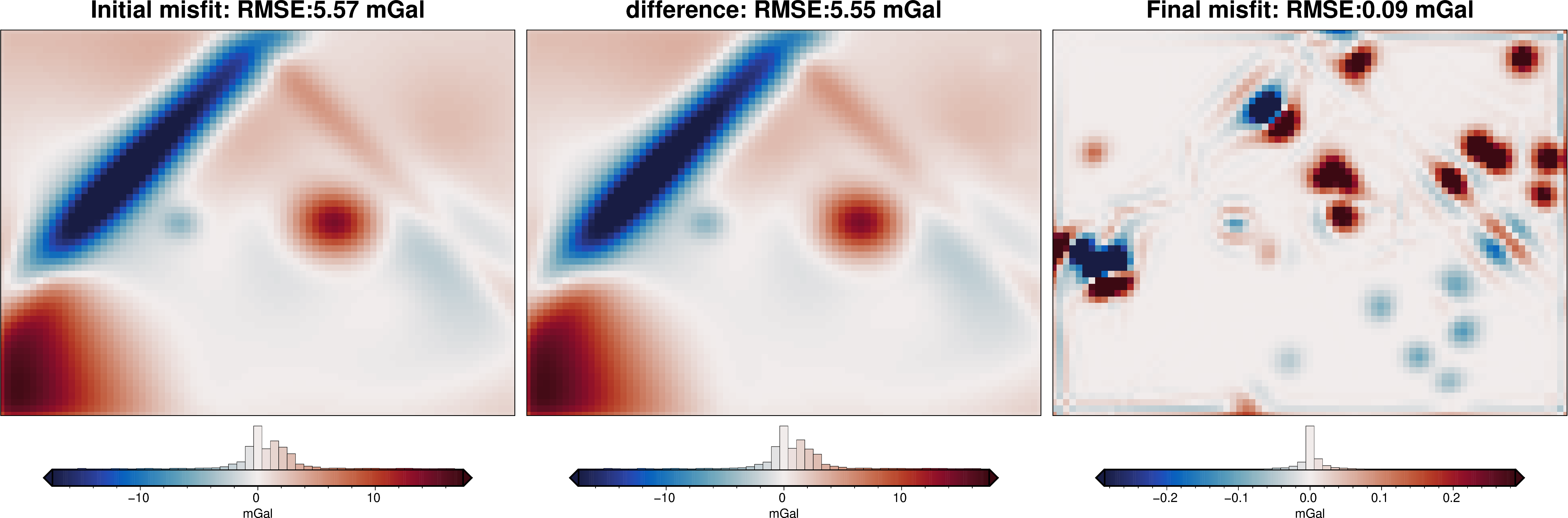
Gravity misfit#
Now we need to calculate the forward gravity of the starting topography. We then can subtract it from our observed gravity to get a starting gravity misfit.
[10]:
# calculate forward gravity of starting prism layer
grav_df["starting_gravity"] = starting_prisms.prism_layer.gravity(
    coordinates=(
        grav_df.easting,
        grav_df.northing,
        grav_df.upward,
    ),
    field="g_z",
    progressbar=True,
)

# estimate regional with the median misfit at constraints
grav_df = regional.regional_constant(
    grav_df=grav_df,
    constraints_df=constraint_points,
)

grav_df
INFO:invert4geom:using median gravity misfit of constraint points for regional field: -0.6170173774402493 mGal
[10]:
| northing | easting | upward | upper_surface_grav | lower_surface_grav | gravity_anomaly | starting_gravity | misfit | reg | res | |
|---|---|---|---|---|---|---|---|---|---|---|
| 0 | 0.0 | 0.0 | 1001.0 | 6.966073 | -0.045074 | 6.920999 | -2.369614 | 9.290613 | -0.617017 | 9.907630 |
| 1 | 0.0 | 500.0 | 1001.0 | 8.535965 | -0.049696 | 8.486269 | -2.999030 | 11.485299 | -0.617017 | 12.102316 |
| 2 | 0.0 | 1000.0 | 1001.0 | 8.802495 | -0.055773 | 8.746722 | -3.206840 | 11.953563 | -0.617017 | 12.570580 |
| 3 | 0.0 | 1500.0 | 1001.0 | 8.723351 | -0.063154 | 8.660197 | -3.262863 | 11.923061 | -0.617017 | 12.540078 |
| 4 | 0.0 | 2000.0 | 1001.0 | 8.519803 | -0.071496 | 8.448307 | -3.247334 | 11.695641 | -0.617017 | 12.312659 |
| ... | ... | ... | ... | ... | ... | ... | ... | ... | ... | ... |
| 4936 | 30000.0 | 38000.0 | 1001.0 | 2.832952 | 0.558197 | 3.391148 | 2.628144 | 0.763004 | -0.617017 | 1.380021 |
| 4937 | 30000.0 | 38500.0 | 1001.0 | 2.816434 | 0.529278 | 3.345712 | 2.567619 | 0.778092 | -0.617017 | 1.395110 |
| 4938 | 30000.0 | 39000.0 | 1001.0 | 2.765486 | 0.491156 | 3.256643 | 2.473866 | 0.782777 | -0.617017 | 1.399794 |
| 4939 | 30000.0 | 39500.0 | 1001.0 | 2.607967 | 0.442645 | 3.050612 | 2.288311 | 0.762301 | -0.617017 | 1.379318 |
| 4940 | 30000.0 | 40000.0 | 1001.0 | 2.060362 | 0.384991 | 2.445353 | 1.780458 | 0.664895 | -0.617017 | 1.281913 |
4941 rows × 10 columns
[11]:
grav_grid = grav_df.set_index(["northing", "easting"]).to_xarray()

fig = maps.plot_grd(
    grav_grid.gravity_anomaly,
    fig_height=10,
    title="Topo free disturbance",
    cmap="viridis",
    hist=True,
    cbar_label="mGal",
    frame=["nSWe", "xaf10000", "yaf10000"],
)

fig = maps.plot_grd(
    grav_grid.misfit,
    fig=fig,
    origin_shift="x",
    fig_height=10,
    title="Misfit",
    cmap="viridis",
    hist=True,
    cbar_label="mGal",
    frame=["nSwE", "xaf10000", "yaf10000"],
)

fig = maps.plot_grd(
    grav_grid.reg,
    fig=fig,
    origin_shift="x",
    fig_height=10,
    title="Regional misfit",
    cmap="viridis",
    hist=True,
    cbar_label="mGal",
    frame=["nSwE", "xaf10000", "yaf10000"],
)

fig = maps.plot_grd(
    grav_grid.res,
    fig=fig,
    origin_shift="x",
    fig_height=10,
    title="Residual misfit",
    cmap="balance+h0",
    cpt_lims=[-vd.maxabs(grav_grid.res), vd.maxabs(grav_grid.res)],
    hist=True,
    cbar_label="mGal",
    frame=["nSwE", "xaf10000", "yaf10000"],
    points=constraint_points,
    points_style="x.15c",
)
fig.show()
makecpt [ERROR]: Option T: min >= max
WARNING:polartoolkit:supplied min value is greater or equal to max value
ERROR:polartoolkit:Module 'makecpt' failed with status code 72:
makecpt [ERROR]: Option T: min >= max
Traceback (most recent call last):
  File "/home/mattd/miniforge3/envs/invert4geom/lib/python3.12/site-packages/polartoolkit/maps.py", line 992, in set_cmap
    pygmt.makecpt(
  File "/home/mattd/miniforge3/envs/invert4geom/lib/python3.12/site-packages/pygmt/helpers/decorators.py", line 595, in new_module
    return module_func(*args, **kwargs)
           ^^^^^^^^^^^^^^^^^^^^^^^^^^^^
  File "/home/mattd/miniforge3/envs/invert4geom/lib/python3.12/site-packages/pygmt/helpers/decorators.py", line 758, in new_module
    return module_func(*bound.args, **bound.kwargs)
           ^^^^^^^^^^^^^^^^^^^^^^^^^^^^^^^^^^^^^^^^
  File "/home/mattd/miniforge3/envs/invert4geom/lib/python3.12/site-packages/pygmt/src/makecpt.py", line 164, in makecpt
    lib.call_module(module="makecpt", args=build_arg_list(kwargs, outfile=output))
  File "/home/mattd/miniforge3/envs/invert4geom/lib/python3.12/site-packages/pygmt/clib/session.py", line 659, in call_module
    raise GMTCLibError(msg)
pygmt.exceptions.GMTCLibError: Module 'makecpt' failed with status code 72:
makecpt [ERROR]: Option T: min >= max
makecpt [ERROR]: Option T: min >= max
WARNING:polartoolkit:supplied min value is greater or equal to max value
ERROR:polartoolkit:Module 'makecpt' failed with status code 72:
makecpt [ERROR]: Option T: min >= max
Traceback (most recent call last):
  File "/home/mattd/miniforge3/envs/invert4geom/lib/python3.12/site-packages/polartoolkit/maps.py", line 992, in set_cmap
    pygmt.makecpt(
  File "/home/mattd/miniforge3/envs/invert4geom/lib/python3.12/site-packages/pygmt/helpers/decorators.py", line 595, in new_module
    return module_func(*args, **kwargs)
           ^^^^^^^^^^^^^^^^^^^^^^^^^^^^
  File "/home/mattd/miniforge3/envs/invert4geom/lib/python3.12/site-packages/pygmt/helpers/decorators.py", line 758, in new_module
    return module_func(*bound.args, **bound.kwargs)
           ^^^^^^^^^^^^^^^^^^^^^^^^^^^^^^^^^^^^^^^^
  File "/home/mattd/miniforge3/envs/invert4geom/lib/python3.12/site-packages/pygmt/src/makecpt.py", line 164, in makecpt
    lib.call_module(module="makecpt", args=build_arg_list(kwargs, outfile=output))
  File "/home/mattd/miniforge3/envs/invert4geom/lib/python3.12/site-packages/pygmt/clib/session.py", line 659, in call_module
    raise GMTCLibError(msg)
pygmt.exceptions.GMTCLibError: Module 'makecpt' failed with status code 72:
makecpt [ERROR]: Option T: min >= max
WARNING:polartoolkit:Grid/points are a constant value, can't make a colorbar histogram!
Inversion without weighting grid#
[12]:
logging.getLogger().setLevel(logging.WARN)
# set kwargs to pass to the inversion
kwargs = {
"solver_damping": 0.05,
# set stopping criteria
"max_iterations": 300,
"l2_norm_tolerance": 0.3,
"delta_l2_norm_tolerance": 1.005,
}
# run the inversion workflow
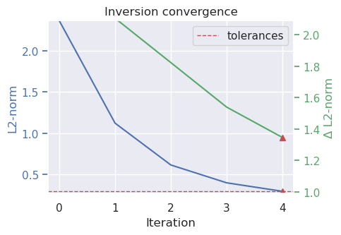
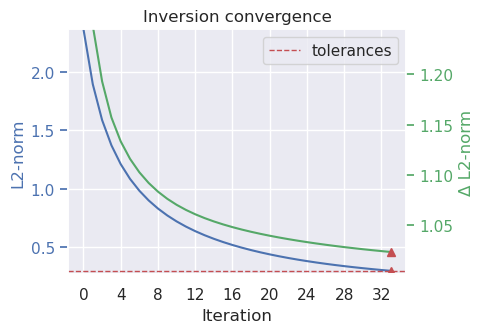
results = inversion.run_inversion_workflow(
grav_df=grav_df,
starting_prisms=starting_prisms,
plot_dynamic_convergence=True,
fname="../tmp/non_weighted_inversion",
**kwargs,
)
# collect the results
topo_results, grav_results, parameters, elapsed_time = results
[13]:
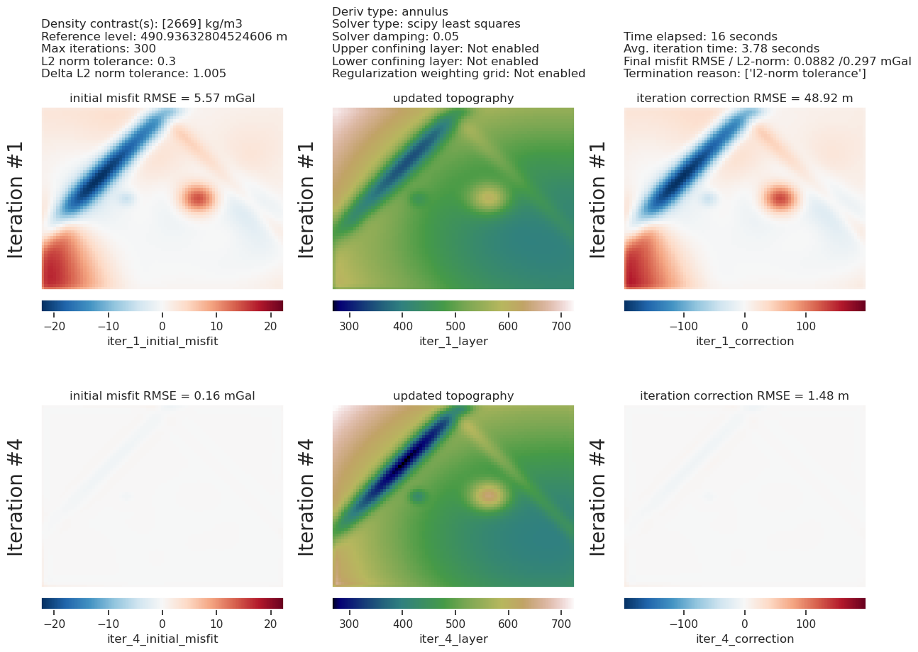
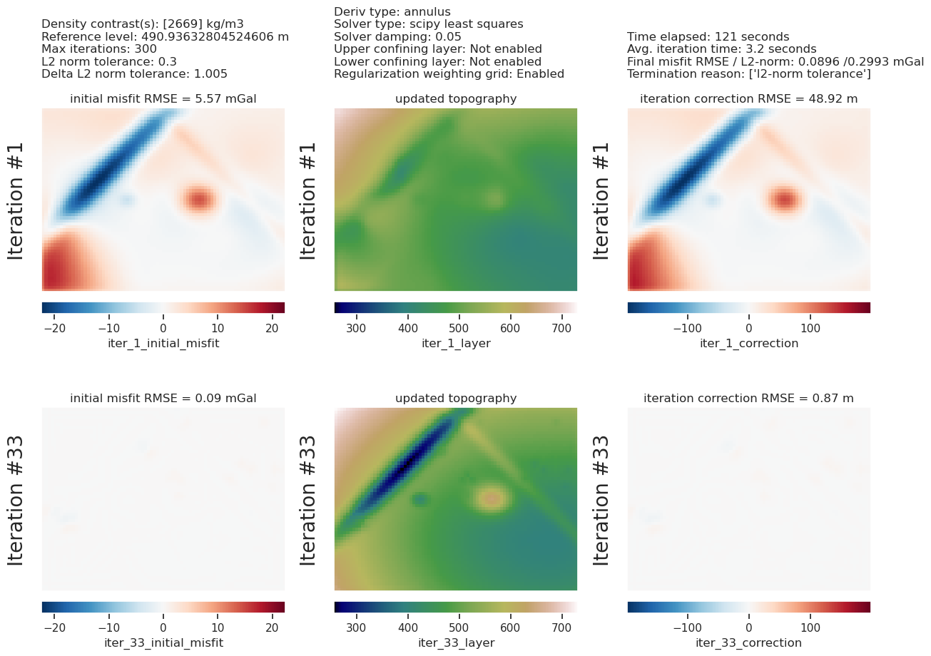
plotting.plot_inversion_results(
grav_results,
topo_results,
parameters,
region,
iters_to_plot=2,
plot_iter_results=True,
plot_topo_results=True,
plot_grav_results=True,
)
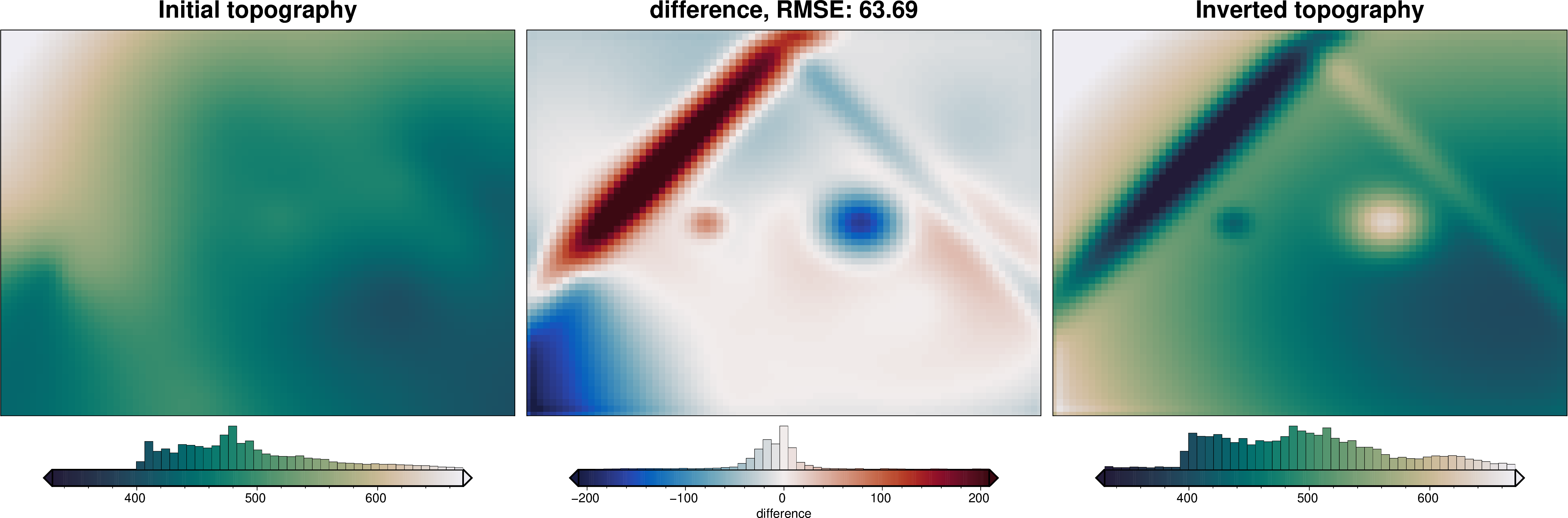
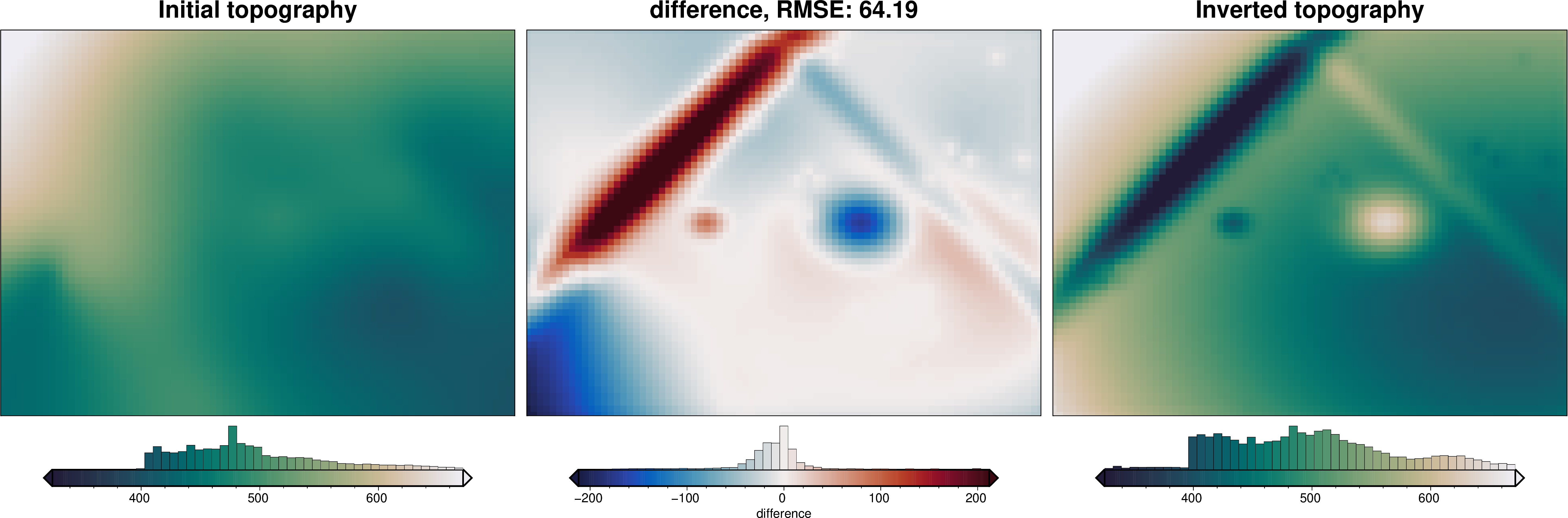
final_topography = topo_results.set_index(["northing", "easting"]).to_xarray().topo
_ = polar_utils.grd_compare(
true_topography,
final_topography,
plot=True,
grid1_name="True topography",
grid2_name="Inverted topography",
robust=True,
hist=True,
inset=False,
verbose="q",
title="difference",
grounding_line=False,
reverse_cpt=True,
cmap="rain",
points=constraint_points,
points_style="x.3c",
)
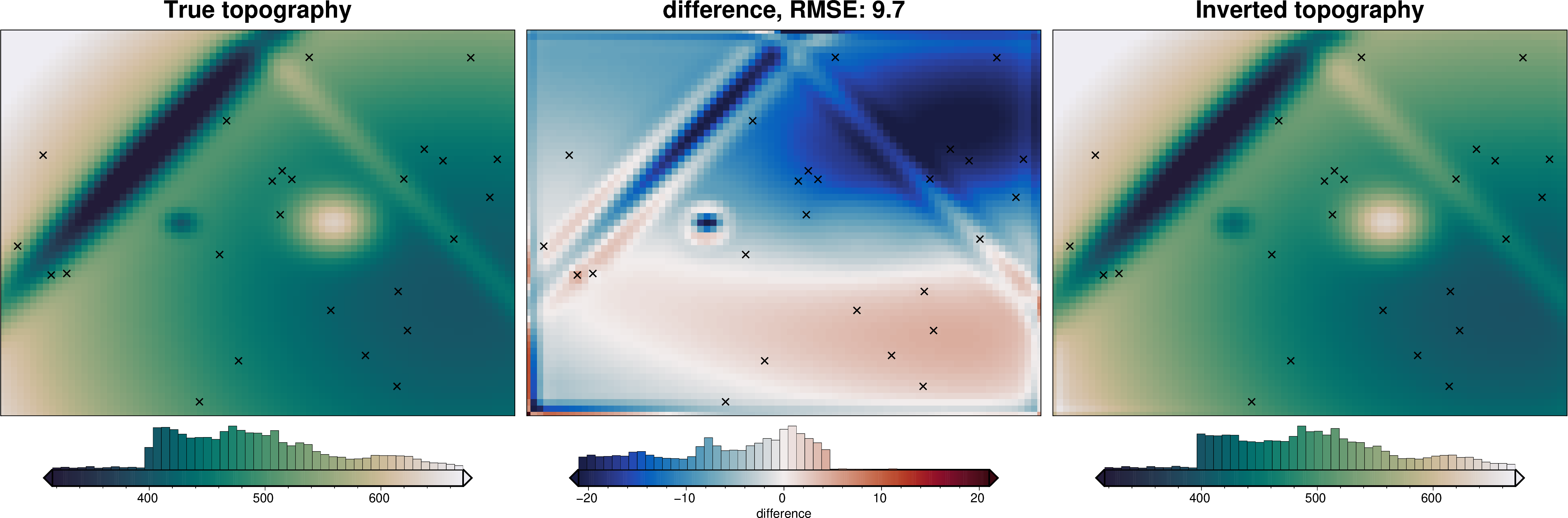
[14]:
# sample the inverted topography at the constraint points
constraint_points = utils.sample_grids(
    constraint_points,
    final_topography,
    "inverted_topography",
)

rmse_without_weighting = utils.rmse(
    constraint_points.upward - constraint_points.inverted_topography
)
max_error_without_weighting = vd.maxabs(
    constraint_points.upward - constraint_points.inverted_topography
)

print(f"RMSE at constraints: {round(rmse_without_weighting, 1)} m")
print(f"max error at constraints: {round(max_error_without_weighting, 1)} m")
RMSE at constraints: 10.6 m
max error at constraints: 20.3 m
Weighting grid#
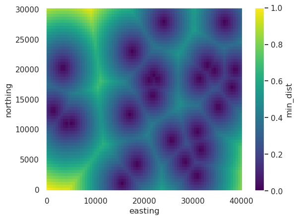
To force the inversion to adhere to the starting model we need to supply a weighting grid. At each iteration, the correction grid is multiplied by this weighting grid to alter the iteration’s correction. Therefore, this weighting grid should be ~0 at the constraints, so that they aren’t altered from the starting model. These values should increase to ~1 at a distance to allow the inversion to be un-affected at locations far from constraints.
[15]:
# calculate the distance between each grid cell and the nearest constraint, then
# normalize those values between 0 and 1
weighting_grid = utils.normalized_mindist(
    constraint_points,
    starting_prisms,
    low=0,
    high=1,
)
weighting_grid.plot()
[15]:
<matplotlib.collections.QuadMesh at 0x7efc2daf8170>
Perform inversion#
Now we can perform the inversion, supplying the argument apply_weighting_grid=True and ensuring that the weighting grid is included as the weights variable to the argument prism_layer.
[16]:
logging.getLogger().setLevel(logging.WARN)

# run the inversion workflow
results = inversion.run_inversion_workflow(
    grav_df=grav_df,
    starting_prisms=starting_prisms,
    plot_dynamic_convergence=True,
    # enable the use of weights
    apply_weighting_grid=True,
    weighting_grid=weighting_grid,
    fname="../tmp/weighted_inversion",
    **kwargs,
)

# collect the results
topo_results, grav_results, parameters, elapsed_time = results
[17]:
plotting.plot_inversion_results(
    grav_results,
    topo_results,
    parameters,
    region,
    iters_to_plot=2,
    plot_iter_results=True,
    plot_topo_results=True,
    plot_grav_results=True,
)

final_topography = topo_results.set_index(["northing", "easting"]).to_xarray().topo

_ = polar_utils.grd_compare(
    true_topography,
    final_topography,
    plot=True,
    grid1_name="True topography",
    grid2_name="Inverted topography",
    robust=True,
    hist=True,
    inset=False,
    verbose="q",
    title="difference",
    grounding_line=False,
    reverse_cpt=True,
    cmap="rain",
    points=constraint_points,
    points_style="x.3c",
)

As we can see by the low error values surrounding the constraints (black crosses), include the weighting grid has help the inversion adhere to the constraints. We can sample the inverted topography at the constraints and compare with the constraints true values.
[18]:
# sample the inverted topography at the constraint points
constraint_points = utils.sample_grids(
    constraint_points,
    final_topography,
    "inverted_topography",
)

rmse_with_weighting = utils.rmse(
    constraint_points.upward - constraint_points.inverted_topography
)
max_error_with_weighting = vd.maxabs(
    constraint_points.upward - constraint_points.inverted_topography
)

print("without weighting:")
print(f"\tRMSE at constraints : {round(rmse_without_weighting, 1)} m")
print(f"\tmax error at constraints: {round(max_error_without_weighting, 1)} m")

print("with weighting:")
print(f"\tRMSE at constraints: {round(rmse_with_weighting, 1)} m")
print(f"\tmax error at constraints: {round(max_error_with_weighting, 1)} m")
without weighting:
        RMSE at constraints : 10.6 m
        max error at constraints: 20.3 m
with weighting:
        RMSE at constraints: 2.0 m
        max error at constraints: 4.2 m
While this inversion’s results are very similar to the inversion without using the weighting grid, the RMSE at the constraint points has been lowered, showing the inversion is more closely adhering to these constraints.
Note at we increased the max iterations allowed. This is necessary since with the weighting grid will require many more iterations to get to a similar outcome.