Constraining the inversion#
This notebook explains some additional approaches we employ to smallness regularization. In this scenario, we aim to invert for the sediment-basement contact with some outcropping basement at the surface. We employ the following constraints:
Inverted basement should not cross the surface topography (
upper_confining_layer)Inverted basement should not go below 100 m elevation ((
lower_confining_layer))Limit changes to starting model in areas of known basement depth using a
weighting grid.For outcropping basement locations, exclude prisms from the inversion to reduce computation.
Again, we will use the same synthetic data from the past examples.
Import packages#
[1]:
# set EPSG for plotting functions
import os

import numpy as np
import polartoolkit as ptk
import verde as vd
import xarray as xr

import invert4geom

os.environ["POLARTOOLKIT_EPSG"] = "3857"
/home/mdtanker/miniforge3/envs/invert4geom/lib/python3.12/site-packages/UQpy/__init__.py:6: UserWarning:

pkg_resources is deprecated as an API. See https://setuptools.pypa.io/en/latest/pkg_resources.html. The pkg_resources package is slated for removal as early as 2025-11-30. Refrain from using this package or pin to Setuptools<81.
Create observed gravity data#
[2]:
true_surface_topography, _, _, _ = invert4geom.load_synthetic_model(
spacing=500,
region=(0, 40000, 0, 30000),
zref=0,
)
# create lower synthetic topography data
true_basement_topography = invert4geom.synthetic_topography_regional(
spacing=500,
region=(0, 40000, 0, 30000),
scale=3,
yoffset=600,
)
# clip lower topography to be always below true topography
true_basement_topography = xr.where(
true_basement_topography < true_surface_topography,
true_basement_topography,
true_surface_topography,
)
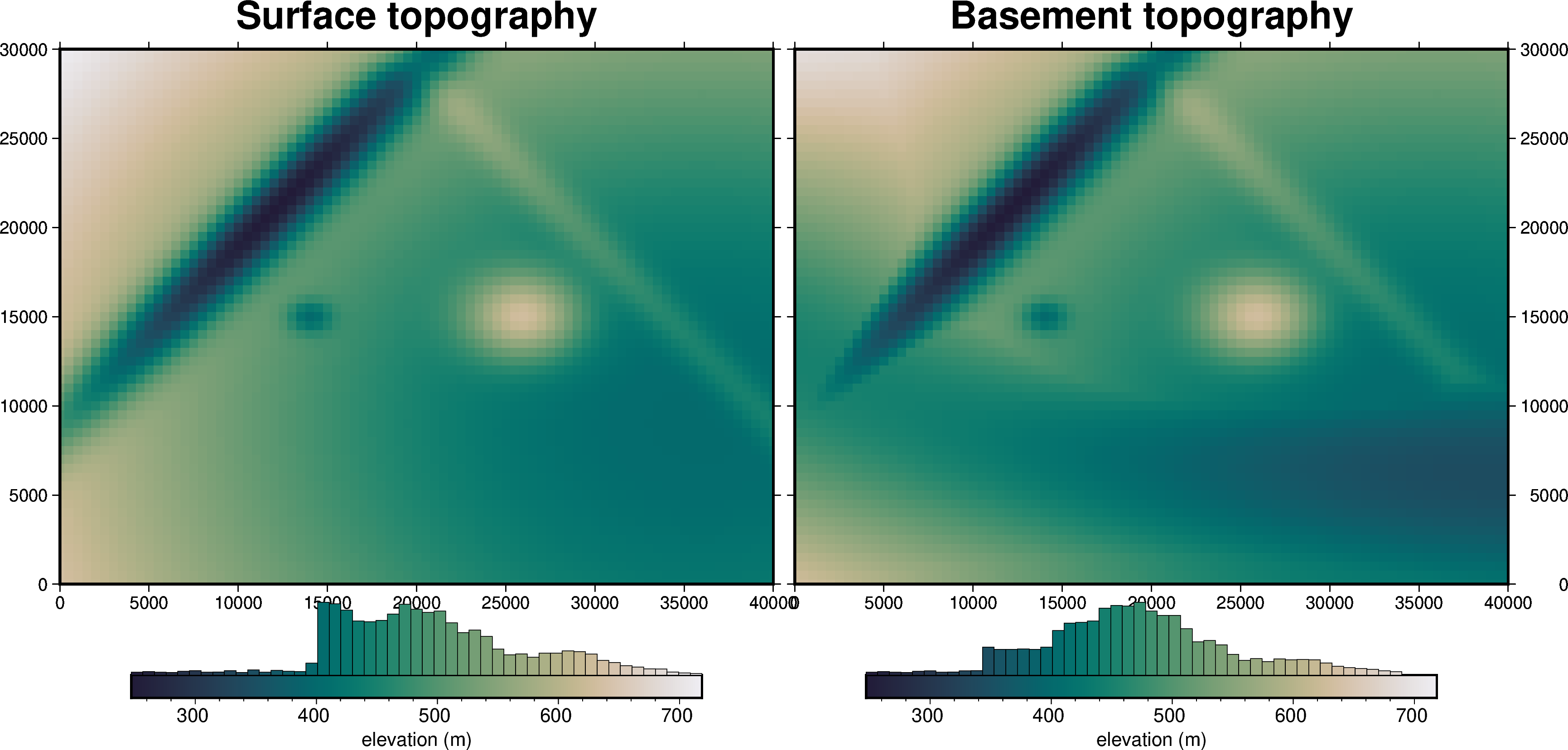
cpt_lims = ptk.get_combined_min_max([true_surface_topography, true_basement_topography])
fig = ptk.plot_grid(
true_surface_topography,
fig_height=10,
title="Surface topography",
cmap="rain",
reverse_cpt=True,
cpt_lims=cpt_lims,
hist=True,
cbar_label="elevation (m)",
frame=["nSWe", "xaf10000", "yaf10000"],
)
fig = ptk.plot_grid(
true_basement_topography,
fig=fig,
origin_shift="x",
fig_height=10,
title="Basement topography",
cmap="rain",
reverse_cpt=True,
cpt_lims=cpt_lims,
hist=True,
cbar_label="elevation (m)",
frame=["nSwE", "xaf10000", "yaf10000"],
)
fig.show()
[3]:
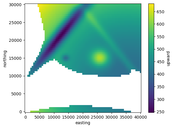
outcropping_basement = true_basement_topography.where(
    true_basement_topography == true_surface_topography,
)
outcropping_basement.plot()
[3]:
<matplotlib.collections.QuadMesh at 0x7f42477c7950>
[4]:
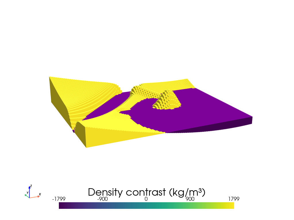
# the first density contrast is between sediment (~1800 kg/m3) and air (~1 kg/m3)
surface_density_contrast = 1800 - 1

surface_model = invert4geom.create_model(
    zref=true_surface_topography.to_numpy().mean(),
    density_contrast=surface_density_contrast,
    topography=true_surface_topography.to_dataset(name="upward"),
)

surface_model.inv.plot_model(
    color_by="density",
    zscale=30,
)
[5]:
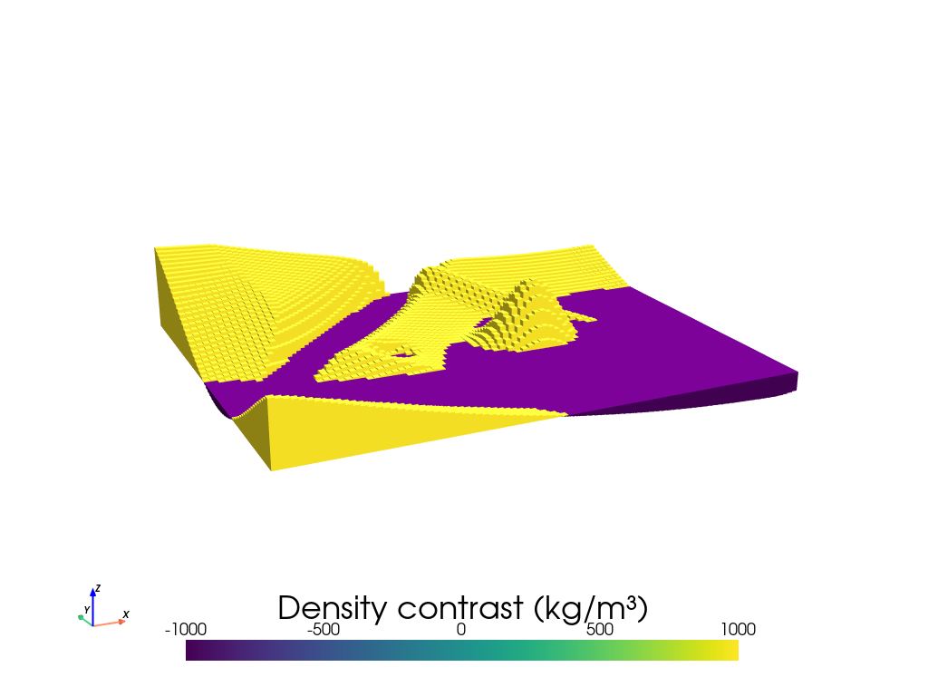
# the second density contrast is between basement (~2800 kg/m3) and sediment (~1800 kg/m3)
basement_density_contrast = 2800 - 1800

basement_model = invert4geom.create_model(
    zref=true_basement_topography.to_numpy().mean(),
    # zref = 0,
    density_contrast=basement_density_contrast,
    topography=true_basement_topography.to_dataset(name="upward"),
)

basement_model.inv.plot_model(
    color_by="density",
    zscale=30,
)
[6]:
# make pandas dataframe of locations to calculate gravity
# this represents the station locations of a gravity survey
# create lists of coordinates
coords = vd.grid_coordinates(
    spacing=500,
    region=(0, 40000, 0, 30000),
    pixel_register=False,
    extra_coords=1001,  # survey elevation
)

observations = vd.make_xarray_grid(
    (coords[0], coords[1]),
    data=coords[2],
    data_names="upward",
    dims=("northing", "easting"),
)

grav_data = invert4geom.create_data(observations)

# forward gravity of upper and lower prisms
grav_data.inv.forward_gravity(surface_model, "surface_grav")
grav_data.inv.forward_gravity(basement_model, "basement_grav")

grav_data["observed_gravity"] = grav_data.surface_grav + grav_data.basement_grav
grav_data
[6]:
<xarray.Dataset> Size: 159kB
Dimensions:           (northing: 61, easting: 81)
Coordinates:
  * northing          (northing) float64 488B 0.0 500.0 1e+03 ... 2.95e+04 3e+04
  * easting           (easting) float64 648B 0.0 500.0 1e+03 ... 3.95e+04 4e+04
Data variables:
    upward            (northing, easting) float64 40kB 1.001e+03 ... 1.001e+03
    surface_grav      (northing, easting) float64 40kB 4.695 5.754 ... 1.389
    basement_grav     (northing, easting) float64 40kB 2.747 3.407 ... 1.131
    observed_gravity  (northing, easting) float64 40kB 7.443 9.161 ... 2.519
Attributes:
    region:        (0.0, 40000.0, 0.0, 30000.0)
    spacing:       500.0
    buffer_width:  3000.0
    inner_region:  (3000.0, 37000.0, 3000.0, 27000.0)
    dataset_type:  data
    model_type:    prisms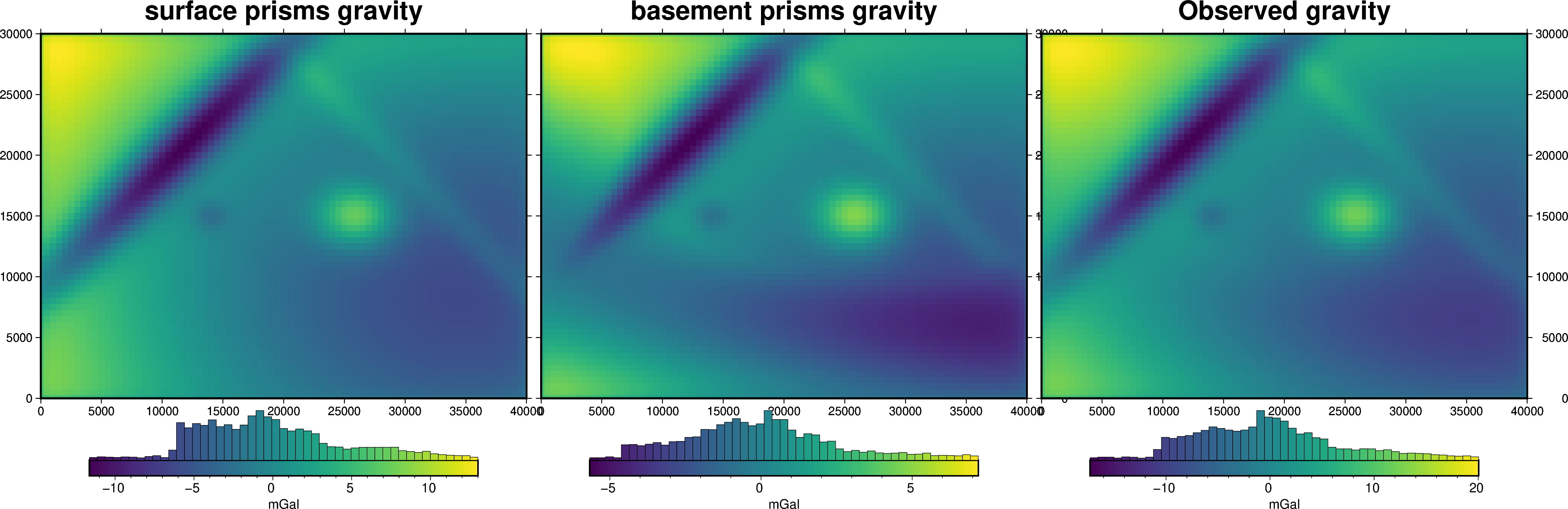
coord_names: ('easting', 'northing')[7]:
fig = ptk.plot_grid(
    grav_data.surface_grav,
    fig_height=10,
    title="surface prisms gravity",
    cmap="viridis",
    hist=True,
    cbar_label="mGal",
    frame=["nSWe", "xaf10000", "yaf10000"],
)

fig = ptk.plot_grid(
    grav_data.basement_grav,
    fig=fig,
    origin_shift="x",
    fig_height=10,
    title="basement prisms gravity",
    cmap="viridis",
    hist=True,
    cbar_label="mGal",
    frame=["nSwE", "xaf10000", "yaf10000"],
)

fig = ptk.plot_grid(
    grav_data.observed_gravity,
    fig=fig,
    origin_shift="x",
    fig_height=10,
    title="Observed gravity",
    cmap="viridis",
    hist=True,
    cbar_label="mGal",
    frame=["nSwE", "xaf10000", "yaf10000"],
)

fig.show()
Gravity anomaly#
The input gravity anomaly should be corrected for topographic mass (i.e. a Bouguer anomaly). We will forward model the gravity effect of topography and remove it to get the Bouguer anomaly. We already calculated this to create the observed gravity, so we will just subtract it.
[8]:
grav_data["gravity_anomaly"] = grav_data.observed_gravity - grav_data.surface_grav
Create starting model#
Create a starting model from the interpolation of the 10 constraint points. Also use each grid cell of outcropping basement as an additional constraint point so the starting model equals the basement where it outcrops.
During interpolation, use upper_confining_layer and lower_confining_layer to make the starting model doesn’t ever go above the surface, or below a flat layer at 100 m elevation.
[9]:
# make all points where basement outcrops as constraint points
constraint_points = outcropping_basement.to_dataframe().reset_index().dropna()
constraint_points
[9]:
| northing | easting | upward | |
|---|---|---|---|
| 4 | 0.0 | 2000.0 | 617.558404 |
| 5 | 0.0 | 2500.0 | 612.739407 |
| 6 | 0.0 | 3000.0 | 607.952814 |
| 7 | 0.0 | 3500.0 | 603.200063 |
| 8 | 0.0 | 4000.0 | 598.482591 |
| ... | ... | ... | ... |
| 4936 | 30000.0 | 38000.0 | 540.007207 |
| 4937 | 30000.0 | 38500.0 | 540.369652 |
| 4938 | 30000.0 | 39000.0 | 540.812371 |
| 4939 | 30000.0 | 39500.0 | 541.335200 |
| 4940 | 30000.0 | 40000.0 | 541.937950 |
2870 rows × 3 columns
[10]:
# grid the sampled values using verde
starting_topography_kwargs = dict(
method="splines",
region=basement_model.region,
spacing=basement_model.spacing,
constraints_df=constraint_points,
dampings=None,
upper_confining_layer=true_surface_topography,
lower_confining_layer=xr.full_like(true_surface_topography, 100),
)
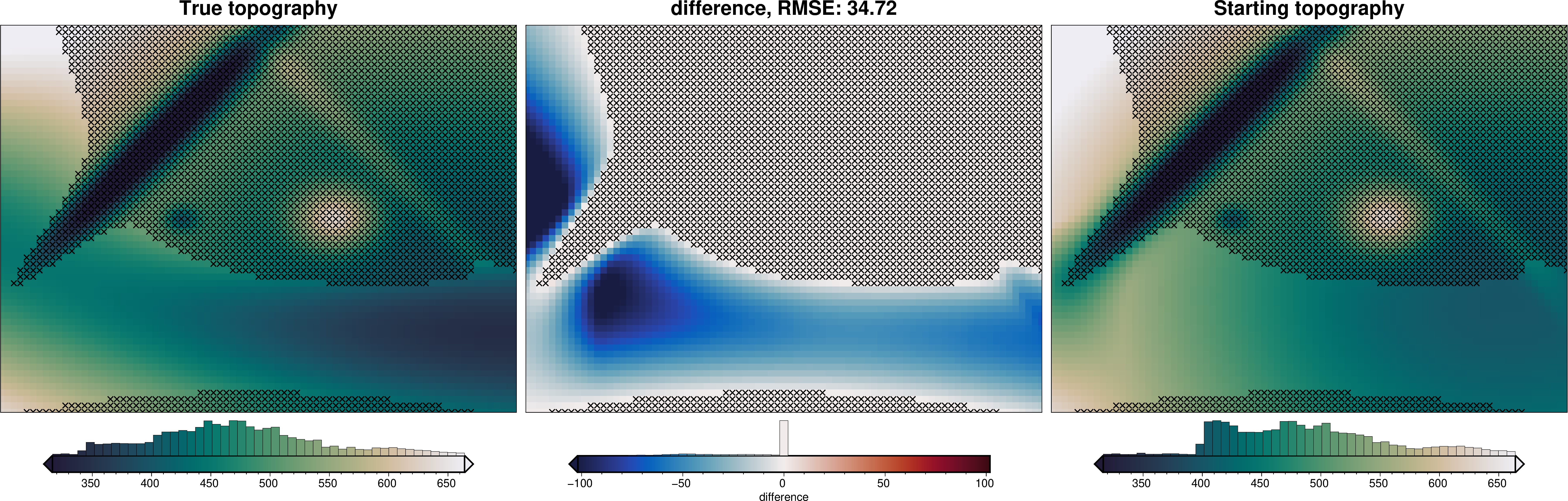
starting_topography = invert4geom.create_topography(**starting_topography_kwargs)
_ = ptk.grid_compare(
true_basement_topography,
starting_topography.upward,
grid1_name="True topography",
grid2_name="Starting topography",
robust=True,
hist=True,
inset=False,
verbose="q",
title="difference",
reverse_cpt=True,
cmap="rain",
points=constraint_points,
points_style="x.3c",
)
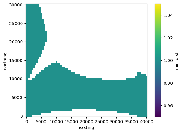
Add a mask variable to the starting topography. Grid cells with a mask of NaN denote where basement depth is known, and these grid cells are excluded from the inversion and thus not altered. Additionally, since these prisms are excluded, the inversion will be faster due to fewer forward calculations, and a smaller Jacobian matrix.
[11]:
# distance to nearest constraint
min_dist = invert4geom.normalized_mindist(
    constraint_points,
    starting_topography.upward,
)
mask = xr.where(min_dist < 500, np.nan, 1)
mask.plot()
[11]:
<matplotlib.collections.QuadMesh at 0x7f41ac50f560>
[12]:
ds = starting_topography

# add mask to dataset
ds["mask"] = mask
[13]:
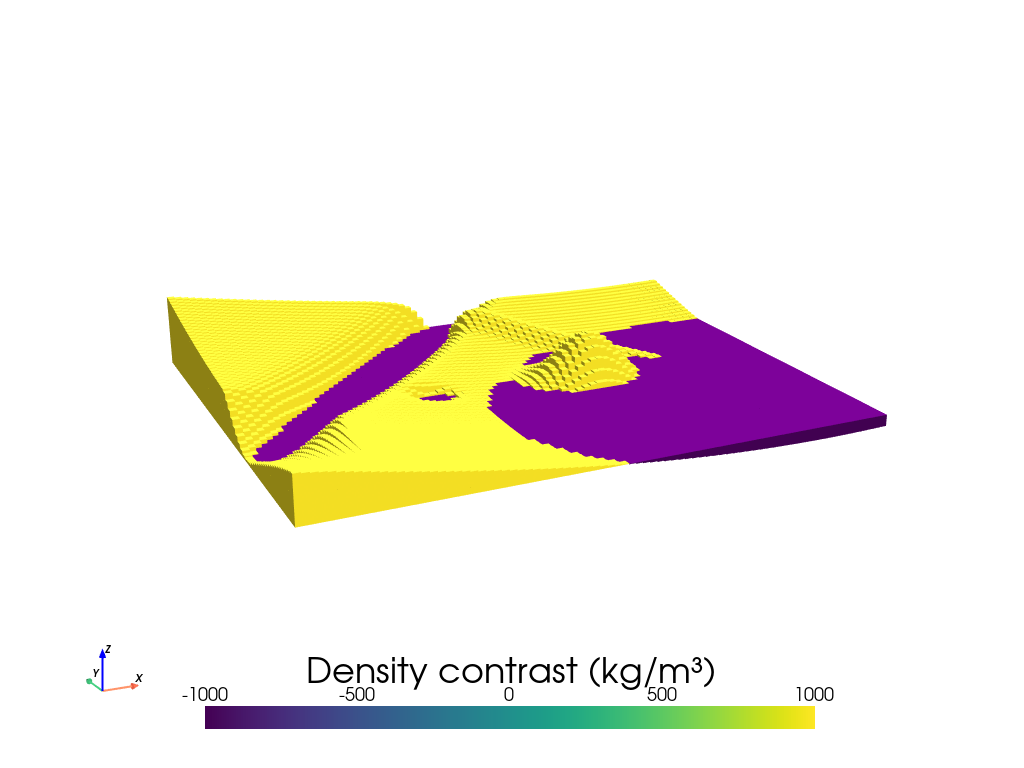
model = invert4geom.create_model(
    zref=true_basement_topography.to_numpy().mean(),
    density_contrast=basement_density_contrast,
    topography=ds,
    upper_confining_layer=true_surface_topography,
)
model.inv.plot_model(
    color_by="density",
    zscale=20,
)
model
[13]:
<xarray.Dataset> Size: 357kB
Dimensions:                (northing: 61, easting: 81)
Coordinates:
  * northing               (northing) float64 488B 0.0 500.0 ... 2.95e+04 3e+04
  * easting                (easting) float64 648B 0.0 500.0 ... 3.95e+04 4e+04
    top                    (northing, easting) float64 40kB 631.5 ... 541.9
    bottom                 (northing, easting) float64 40kB 470.4 ... 470.4
Data variables:
    density                (northing, easting) int64 40kB 1000 1000 ... 1000
    thickness              (northing, easting) float64 40kB 161.1 ... 71.56
    starting_topography    (northing, easting) float64 40kB 631.5 ... 541.9
    topography             (northing, easting) float64 40kB 631.5 ... 541.9
    mask                   (northing, easting) float64 40kB 1.0 1.0 ... nan nan
    upper_confining_layer  (northing, easting) float64 40kB 637.1 ... 541.9
    lower_confining_layer  (northing, easting) float64 40kB nan nan ... nan nan
Attributes:
    zref:              470.3811108689723
    density_contrast:  1000
    region:            (0.0, 40000.0, 0.0, 30000.0)
    spacing:           500.0
    buffer_width:      0
    inner_region:      (0.0, 40000.0, 0.0, 30000.0)
    dataset_type:      model
    model_type:        prisms
coord_names: ('easting', 'northing')Gravity misfit#
Now we need to calculate the forward gravity of the starting topography. We then can subtract it from our observed gravity to get a starting gravity misfit.
[14]:
grav_data.inv.forward_gravity(model, progressbar=True)

grav_data.inv.regional_separation(
    method="constant",
    constant=0,
)
grav_data
[14]:
<xarray.Dataset> Size: 515kB
Dimensions:                   (northing: 61, easting: 81)
Coordinates:
  * northing                  (northing) float64 488B 0.0 500.0 ... 3e+04
  * easting                   (easting) float64 648B 0.0 500.0 ... 4e+04
Data variables: (12/13)
    upward                    (northing, easting) float64 40kB 1.001e+03 ... ...
    surface_grav              (northing, easting) float64 40kB 4.695 ... 1.389
    basement_grav             (northing, easting) float64 40kB 2.747 ... 1.131
    observed_gravity          (northing, easting) float64 40kB 7.443 ... 2.519
    gravity_anomaly           (northing, easting) float64 40kB 2.747 ... 1.131
    forward_gravity           (northing, easting) float64 40kB 2.808 ... 1.133
    ...                        ...
    reg                       (northing, easting) float64 40kB 0.0 0.0 ... 0.0
    res                       (northing, easting) float64 40kB -0.0612 ... -0...
    starting_forward_gravity  (northing, easting) float64 40kB 2.808 ... 1.133
    starting_misfit           (northing, easting) float64 40kB -0.0612 ... -0...
    starting_reg              (northing, easting) float64 40kB 0.0 0.0 ... 0.0
    starting_res              (northing, easting) float64 40kB -0.0612 ... -0...
Attributes:
    region:        (0.0, 40000.0, 0.0, 30000.0)
    spacing:       500.0
    buffer_width:  3000.0
    inner_region:  (3000.0, 37000.0, 3000.0, 27000.0)
    dataset_type:  data
    model_type:    prisms
coord_names: ('easting', 'northing')[15]:
grav_data.inv.plot_anomalies()
makecpt [ERROR]: Option T: min >= max
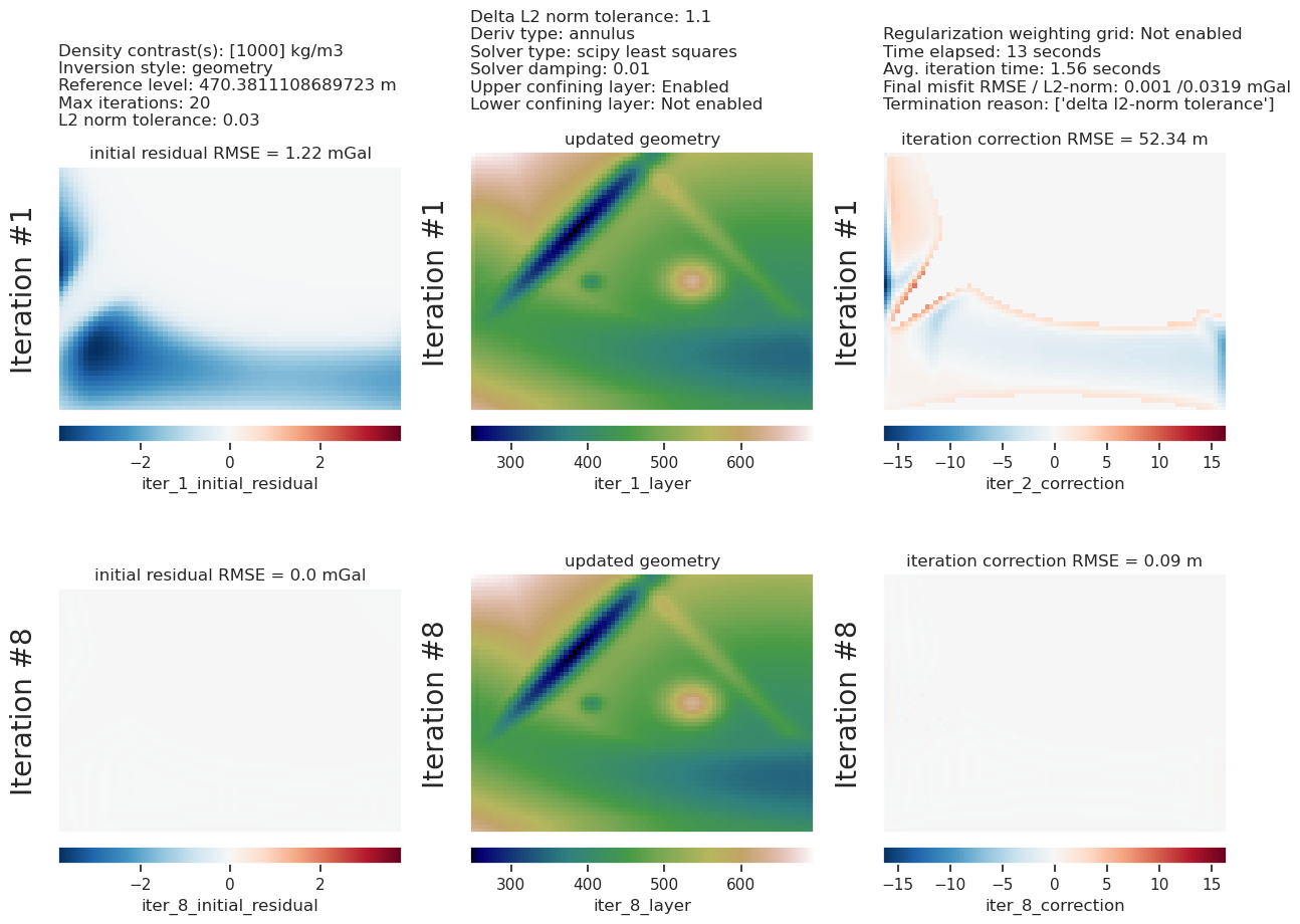
Inversion#
[16]:
# setup the inversion
inv = invert4geom.Inversion(
    grav_data,
    model,
    solver_damping=0.01,
    # set stopping criteria
    max_iterations=20,
    l2_norm_tolerance=0.03,
    delta_l2_norm_tolerance=1.1,
)
[17]:
inv.invert(
    plot_dynamic_convergence=True,
    results_fname="../tmp/constraining_the_inversion",
)
[18]:
inv.stats_df
[18]:
| iteration | rmse | l2_norm | delta_l2_norm | iter_time_sec | |
|---|---|---|---|---|---|
| 0 | 0.0 | 1.217460 | 1.103386 | inf | NaN |
| 1 | 1.0 | 0.033469 | 0.182944 | 6.031264 | 2.057257 |
| 2 | 2.0 | 0.006045 | 0.077747 | 2.353073 | 1.680057 |
| 3 | 3.0 | 0.003238 | 0.056902 | 1.366331 | 1.451522 |
| 4 | 4.0 | 0.002237 | 0.047295 | 1.203141 | 1.441257 |
| 5 | 5.0 | 0.001716 | 0.041427 | 1.141637 | 1.424009 |
| 6 | 6.0 | 0.001395 | 0.037353 | 1.109065 | 1.459401 |
| 7 | 7.0 | 0.001177 | 0.034307 | 1.088795 | 1.470792 |
| 8 | 8.0 | 0.001019 | 0.031914 | 1.074967 | 1.458463 |
[19]:
inv.plot_inversion_results(
    iters_to_plot=2,
)
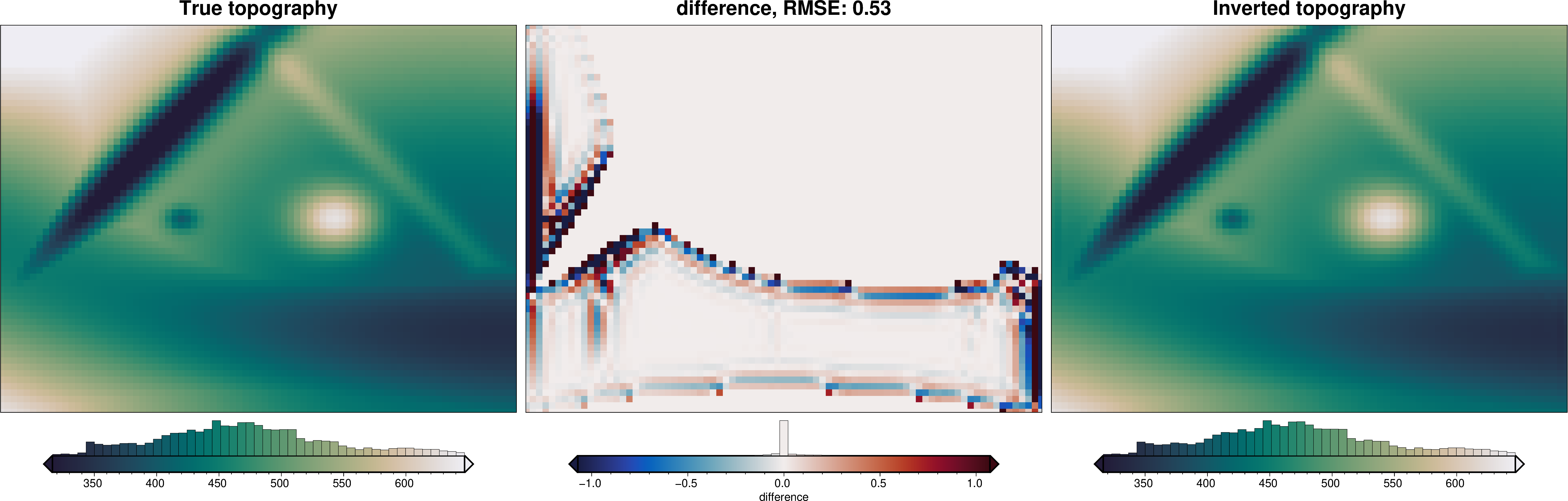
[20]:
_ = ptk.grid_compare(
    true_basement_topography,
    inv.model.topography,
    region=inv.model.inner_region,
    grid1_name="True topography",
    grid2_name="Inverted topography",
    robust=True,
    hist=True,
    inset=False,
    verbose="q",
    title="difference",
    reverse_cpt=True,
    cmap="rain",
)
[21]:
# sample the inverted topography at the constraint points
constraint_points = invert4geom.sample_grids(
    constraint_points,
    inv.model.topography,
    "inverted_topography",
)

rmse_without_weighting = invert4geom.rmse(
    constraint_points.upward - constraint_points.inverted_topography
)
max_error_without_weighting = vd.maxabs(
    constraint_points.upward - constraint_points.inverted_topography
)

print(f"RMSE at constraints: {round(rmse_without_weighting, 1)} m")
print(f"max error at constraints: {round(max_error_without_weighting, 1)} m")
RMSE at constraints: 0.0 m
max error at constraints: 0.0 m