6. Reference level optimization#
In scenarios where you have no prior knowledge of the elevation of the density contrast of interest, we use a flat starting model with an arbitrary reference level. The reference level (zref) is very important to the inversion as different values can vertically shift the inverted topography. Here we present a optimization approach to determine the optimal value for zref. This follows the same approach as the density optimization notebook. To simplify,
we assume we know the appropriate density contrast value to use.
6.1. Import packages#
[1]:
# set EPSG for plotting functions
import os
import pathlib
import pickle

import numpy as np
import polartoolkit as ptk
import verde as vd

import invert4geom

os.environ["POLARTOOLKIT_EPSG"] = "3031"
/home/mdtanker/miniforge3/envs/invert4geom/lib/python3.12/site-packages/UQpy/__init__.py:6: UserWarning:

pkg_resources is deprecated as an API. See https://setuptools.pypa.io/en/latest/pkg_resources.html. The pkg_resources package is slated for removal as early as 2025-11-30. Refrain from using this package or pin to Setuptools<81.
6.2. Create observed gravity data#
6.2.1. True topography#
[2]:
# the density contrast is between rock (~2670 kg/m3) and air (~1 kg/m3)
true_density_contrast = 2670 - 1
(
    true_topography,
    _,
    constraint_points,
    observed_gravity,
) = invert4geom.load_synthetic_model(
    spacing=1000,
    region=(0, 40000, 0, 30000),
    number_of_constraints=10,
    density_contrast=true_density_contrast,
    gravity_noise=0.2,
    plot_topography_diff=False,
)

true_zref = true_topography.values.mean()
print(f"mean of true topography: {true_zref} m ")
mean of true topography: 492.2704164812973 m
For simplicity here we assume that we know the optimal density contrast value and use this when creating our starting model.
What we don’t know in this scenario is what reference elevation zref to use. We will use an optimization of a range of elevations to find the one which is optimal.
Each zref will give a score, and the lowest score will show which zref is optimal.
The score is calculated as the root mean square error between the points of known topography (constraints) and the inverted topography at those points, same as in the past notebook.
6.3. Get a score#
First we need to use the zref value to create the starting model. We will then use this in an inversion to calculate a score.
[3]:
data = invert4geom.create_data(observed_gravity)

# make a flat grid at the height of the zref
grid_coords = vd.grid_coordinates(region=data.region, spacing=data.spacing)
starting_topography = vd.make_xarray_grid(
    grid_coords, data=np.ones_like(grid_coords[0]) * true_zref, data_names="upward"
)

model = invert4geom.create_model(
    zref=300,  # instead of the correct value of ~490 m,
    density_contrast=true_density_contrast,
    topography=starting_topography,
)
[4]:
data.inv.forward_gravity(
    model,
    progressbar=True,
)
In many cases, we want to remove a regional signal from the misfit to isolate the residual signal. In this simple case, we assume there is no regional misfit and set it to 0
[5]:
data.inv.regional_separation(
    method="constant",
    constant=0,
)
[6]:
data.inv.plot_anomalies()
makecpt [ERROR]: Option T: min >= max
[7]:
# setup the inversion
inv = invert4geom.Inversion(
    data,
    model,
    solver_damping=0.1,
    # set stopping criteria
    max_iterations=30,
    l2_norm_tolerance=0.45,
    delta_l2_norm_tolerance=1.005,
)
[8]:
# run inversion, calculate the score
constraints_optimization_object = inv.constraints_score(
    constraints_df=constraint_points
)
inv.constraints_best_score
[8]:
np.float64(195.01017866988633)
6.4. Optimization#
Lets see if we can improve the score with other values for zref. For each zref value we need to recreate the starting prism model, forward calculate its starting gravity, and recalculate the gravity misfit, including the regional and residual components. Then we can re-run the inversion.
This is a classic optimization problem, where we vary the zref to find which value produces the best score. For this we use the Python package Optuna.
For each trial a .pickle file containing the inversion results will be created. Once all trials are complete, all but the best trial’s pickle files will be deleted. Additionally, another .pickle file will be created containing the Optuna study object with all the trial information and results.
By default, optimize_inversion_zref_density_contrast will use a sampler to choose zref values between the provided zref_limits and repeat this n_trials times. This may skip large portions of the parameter space. If instead you would like to systematically test zref values at a constant interval, you can set grid_search to True, and this will test all zref values as defined by:
np.linspace(<<lower zref limit>>, <<upper zref limit>>, n_trials)
[9]:
density_optimization_obj = inv.optimize_inversion_zref_density_contrast(
    constraints_df=constraint_points,
    zref_limits=(400, 600),
    n_trials=6,
    regional_grav_kwargs={
        "method": "constant",
        "constant": 0,
    },
    starting_topography_kwargs={
        "method": "flat",
    },
    # grid_search=True,
    plot_scores=False,
    fname="../tmp/06_zref_optimization",
    fold_progressbar=True,
)
'forward_gravity' already a variable of `grav_ds`, but is being overwritten since calculate_starting_gravity is True
'reg' already a column of `grav_df`, but is being overwritten since calculate_regional_misfit is True
[10]:
# to re-load the study from the saved pickle file
with pathlib.Path("../tmp/06_zref_optimization_study.pickle").open("rb") as f:
    study = pickle.load(f)

# to re-load the inversion results from the saved pickle file
with pathlib.Path("../tmp/06_zref_optimization.pickle").open("rb") as f:
    inv_results = pickle.load(f)
[11]:
fig = invert4geom.plot_scores(
    study.trials_dataframe().value.values,
    study.trials_dataframe().params_zref.values,
    param_name="Reference level",
    logx=False,
    logy=False,
)
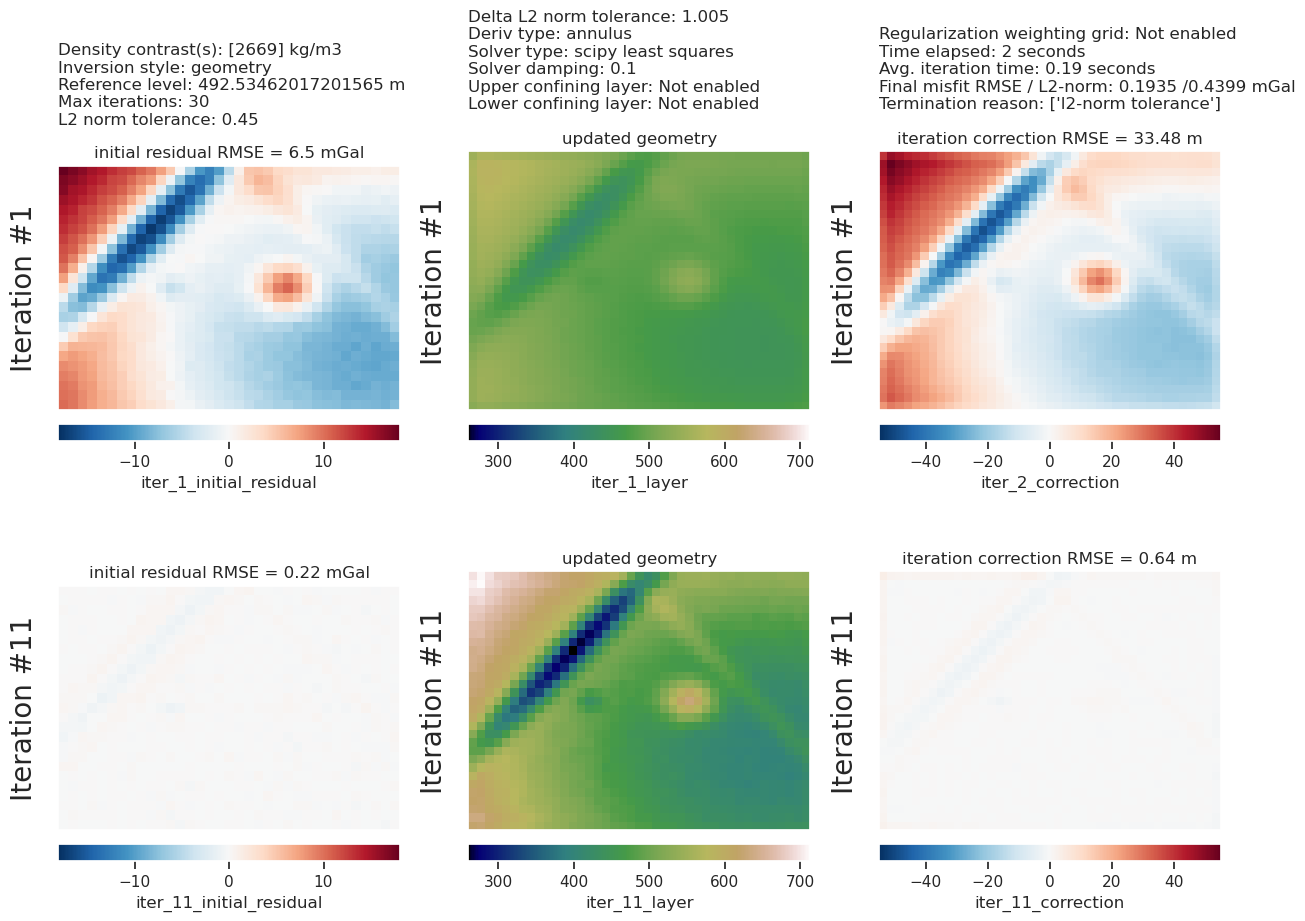
Lets see how the optimization perform by comparing the estimated best reference level value to the true value used to create the observed gravity.
[12]:
print(
    f"True zref value: {true_zref}, best zref from optimization: {inv_results.model.zref}"
)
True zref value: 492.2704164812973, best zref from optimization: 492.53462017201565
[13]:
inv_results.plot_inversion_results(iters_to_plot=2)

_ = ptk.grid_compare(
    true_topography,
    inv_results.model.topography,
    grid1_name="True topography",
    grid2_name="Inverted topography",
    robust=True,
    hist=True,
    inset=False,
    title="difference",
    reverse_cpt=True,
    cmap="rain",
    points=constraint_points,
    points_style="x.3c",
)


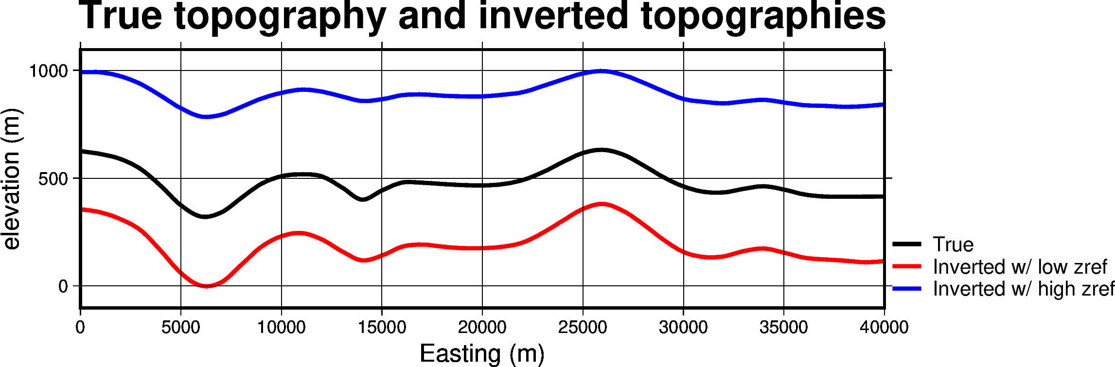
6.5. Run inversion with poor choices of reference level#
[56]:
# set a reference level that is too low
# true zref is ~500 m
low_zref = 200

low_zref_results = invert4geom.run_inversion_workflow(
    grav_ds=data,
    create_starting_topography=True,
    calculate_starting_gravity=True,
    calculate_regional_misfit=True,
    density_contrast=true_density_contrast,
    zref=low_zref,
    fname="../tmp/06_low_zref",
    starting_topography_kwargs={
        "method": "flat",
        "upward": low_zref,
        "region": data.region,
        "spacing": data.spacing,
    },
    regional_grav_kwargs={
        "method": "constant",
        "constant": 0,
    },
    inversion_kwargs={
        "max_iterations": 30,
        "l2_norm_tolerance": 0.45,
        "delta_l2_norm_tolerance": 1.005,
        "solver_damping": 0.1,
    },
)
'forward_gravity' already a variable of `grav_ds`, but is being overwritten since calculate_starting_gravity is True
'reg' already a column of `grav_df`, but is being overwritten since calculate_regional_misfit is True
[55]:
# set a reference level that is too high
# true zref is ~500 m
high_zref = 900

high_zref_results = invert4geom.run_inversion_workflow(
    grav_ds=data,
    create_starting_topography=True,
    calculate_starting_gravity=True,
    calculate_regional_misfit=True,
    density_contrast=true_density_contrast,
    zref=high_zref,
    fname="../tmp/06_high_zref",
    starting_topography_kwargs={
        "method": "flat",
        "upward": high_zref,
        "region": data.region,
        "spacing": data.spacing,
    },
    regional_grav_kwargs={
        "method": "constant",
        "constant": 0,
    },
    inversion_kwargs={
        "max_iterations": 30,
        "l2_norm_tolerance": 0.45,
        "delta_l2_norm_tolerance": 1.005,
        "solver_damping": 0.1,
    },
)
'forward_gravity' already a variable of `grav_ds`, but is being overwritten since calculate_starting_gravity is True
'reg' already a column of `grav_df`, but is being overwritten since calculate_regional_misfit is True
[ ]:
region = low_zref_results.model.inner_region

mean_northing = np.mean([region[2], region[3]])
a = (region[0], mean_northing)
b = (region[1], mean_northing)

data_dict = ptk.make_data_dict(
    [
        "True",
        "Inverted w/ low zref",
        "Inverted w/ high zref",
    ],
    [
        true_topography,
        low_zref_results.model.topography,
        high_zref_results.model.topography,
    ],
    ["black", "red", "blue"],
    axes=[0, 0, 0],
)

fig, _ = ptk.plot_data(
    "points",
    start=a,
    stop=b,
    data_dict=data_dict,
    fig_height=5,
    data_pen_thickness=2,
    data_x_label="Easting (m)",
    data_y0_label="elevation (m)",
    start_label="",
    end_label="",
)
fig.basemap(frame="+tTrue topography and inverted topographies")
fig.show()

data_dict = ptk.make_data_dict(
    [
        "True",
        "Inverted w/ low zref",
        "Inverted w/ high zref",
    ],
    [
        true_topography - true_topography.mean(),
        low_zref_results.model.topography - low_zref_results.model.topography.mean(),
        high_zref_results.model.topography - high_zref_results.model.topography.mean(),
    ],
    ["black", "red", "blue"],
    axes=[0, 0, 0],
)

fig, _ = ptk.plot_data(
    "points",
    start=a,
    stop=b,
    data_dict=data_dict,
    fig_height=5,
    data_pen_thickness=2,
    data_x_label="Easting (m)",
    data_y0_label="elevation (m)",
    start_label="",
    end_label="",
)
fig.basemap(frame="+tw/ means removed")
fig.show()
text [WARNING]: Skipped 1 records as blank - please check input data.
text [WARNING]: Skipped 1 records as blank - please check input data.
text [WARNING]: Skipped 1 records as blank - please check input data.
text [WARNING]: Skipped 1 records as blank - please check input data.
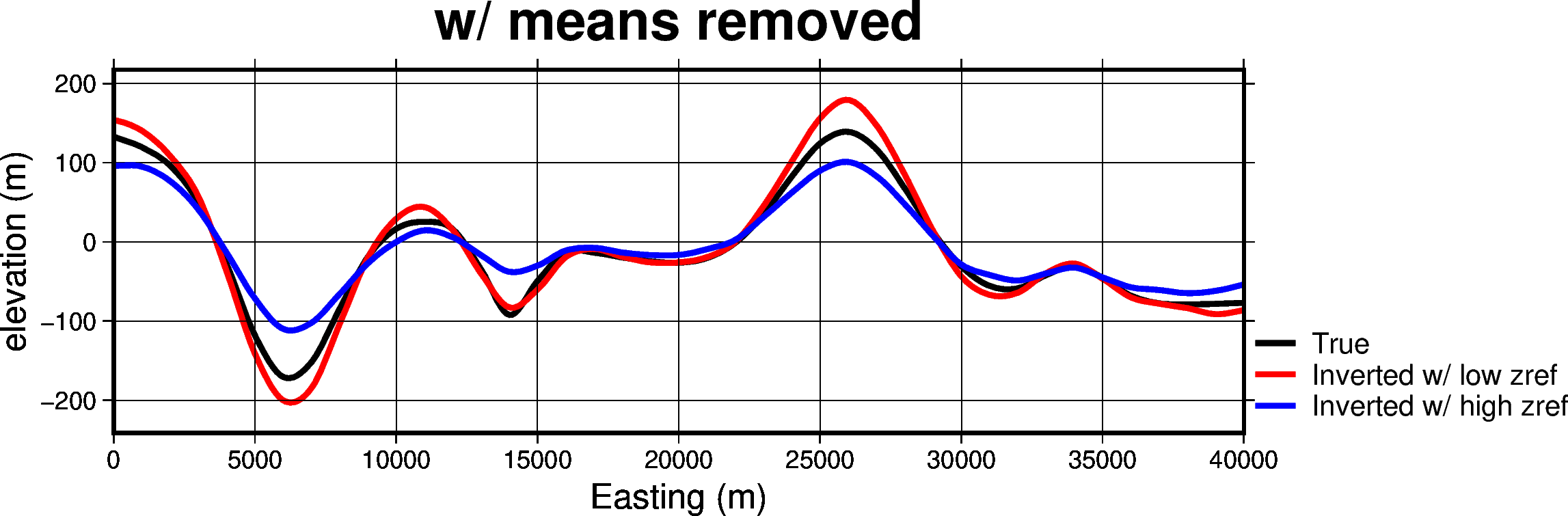
The top profile shows the depth of the inverted topographies with too high and too low of reference levels, compared to the true topography. The below plot is the same, but with the means removed to highlight the difference in amplitudes of features. With too low of a reference level, the amplitude of features is exaggerated, and with too high of a reference level, the amplitude is subdued.
These two inversions both minimized the gravity misfit equally well, highlighting the non-uniqueness of this style of gravity inversion.
[ ]: