Quickstart#
Here is a quick demonstration of some of the main functionality of Invert4Geom. This assumes you are familar with Python and have successfully installed this packaged. See the tutorials for a step-by-step introduction to Invert4Geom, and the how-to guides for more in-depth guides for specific features.
Import packages#
[1]:
import os

import numpy as np
import polartoolkit as ptk
import verde as vd

import invert4geom

os.environ["POLARTOOLKIT_EPSG"] = "3031"
/home/mdtanker/miniforge3/envs/invert4geom/lib/python3.12/site-packages/UQpy/__init__.py:6: UserWarning:

pkg_resources is deprecated as an API. See https://setuptools.pypa.io/en/latest/pkg_resources.html. The pkg_resources package is slated for removal as early as 2025-11-30. Refrain from using this package or pin to Setuptools<81.
Create observed gravity data#
[2]:
true_topography, _, _, observed_gravity = invert4geom.load_synthetic_model(
    spacing=1000,
    region=(0, 40000, 0, 30000),
    density_contrast=2670 - 1,  # density contrast between rock and air
    zref=500,
    gravity_noise=0.2,
    plot_gravity=True,
    plot_topography=True,
)
Initialize the gravity data class#
[3]:
data = invert4geom.create_data(observed_gravity)
Create a starting topography grid#
[4]:
# make a flat grid at 500 m
grid_coords = vd.grid_coordinates(
    spacing=1000,
    region=(0, 40000, 0, 30000),
)
starting_topography = vd.make_xarray_grid(
    grid_coords,
    data=np.ones_like(grid_coords[0]) * 500,
    data_names="upward",
)
Create a model#
[5]:
model = invert4geom.create_model(
    zref=500,
    density_contrast=2670 - 1,
    topography=starting_topography,
)
model
[5]:
<xarray.Dataset> Size: 92kB
Dimensions:                (northing: 31, easting: 41)
Coordinates:
  * northing               (northing) float64 248B 0.0 1e+03 ... 2.9e+04 3e+04
  * easting                (easting) float64 328B 0.0 1e+03 ... 3.9e+04 4e+04
    top                    (northing, easting) float64 10kB 500.0 ... 500.0
    bottom                 (northing, easting) float64 10kB 500.0 ... 500.0
Data variables:
    density                (northing, easting) int64 10kB 2669 2669 ... 2669
    thickness              (northing, easting) float64 10kB 0.0 0.0 ... 0.0 0.0
    starting_topography    (northing, easting) float64 10kB 500.0 ... 500.0
    topography             (northing, easting) float64 10kB 500.0 ... 500.0
    mask                   (northing, easting) float64 10kB 1.0 1.0 ... 1.0 1.0
    upper_confining_layer  (northing, easting) float64 10kB nan nan ... nan nan
    lower_confining_layer  (northing, easting) float64 10kB nan nan ... nan nan
Attributes:
    zref:              500
    density_contrast:  2669
    region:            (0.0, 40000.0, 0.0, 30000.0)
    spacing:           1000.0
    buffer_width:      0
    inner_region:      (0.0, 40000.0, 0.0, 30000.0)
    dataset_type:      model
    model_type:        prisms
coord_names: ('easting', 'northing')[6]:
model.inv.plot_model(show_edges=True)
Gravity misfit#
[7]:
data.inv.forward_gravity(
    model,
    progressbar=True,
)
data.inv.df.head()
[7]:
| northing | easting | upward | gravity_anomaly | forward_gravity | |
|---|---|---|---|---|---|
| 0 | 0.0 | 0.0 | 1000.0 | 9.069604 | -0.0 |
| 1 | 0.0 | 1000.0 | 1000.0 | 9.813227 | -0.0 |
| 2 | 0.0 | 2000.0 | 1000.0 | 9.473334 | -0.0 |
| 3 | 0.0 | 3000.0 | 1000.0 | 8.676493 | -0.0 |
| 4 | 0.0 | 4000.0 | 1000.0 | 7.806311 | -0.0 |
[8]:
data.inv.regional_constant(
    constant=0,
)
data.inv.df.head()
[8]:
| northing | easting | upward | gravity_anomaly | forward_gravity | misfit | reg | res | starting_forward_gravity | starting_misfit | starting_reg | starting_res | |
|---|---|---|---|---|---|---|---|---|---|---|---|---|
| 0 | 0.0 | 0.0 | 1000.0 | 9.069604 | -0.0 | 9.069604 | 0.0 | 9.069604 | -0.0 | 9.069604 | 0.0 | 9.069604 |
| 1 | 0.0 | 1000.0 | 1000.0 | 9.813227 | -0.0 | 9.813227 | 0.0 | 9.813227 | -0.0 | 9.813227 | 0.0 | 9.813227 |
| 2 | 0.0 | 2000.0 | 1000.0 | 9.473334 | -0.0 | 9.473334 | 0.0 | 9.473334 | -0.0 | 9.473334 | 0.0 | 9.473334 |
| 3 | 0.0 | 3000.0 | 1000.0 | 8.676493 | -0.0 | 8.676493 | 0.0 | 8.676493 | -0.0 | 8.676493 | 0.0 | 8.676493 |
| 4 | 0.0 | 4000.0 | 1000.0 | 7.806311 | -0.0 | 7.806311 | 0.0 | 7.806311 | -0.0 | 7.806311 | 0.0 | 7.806311 |
[9]:
data.inv.plot_anomalies()
makecpt [ERROR]: Option T: min >= max
Initialize the Inversion class#
[10]:
inv = invert4geom.Inversion(
    data,
    model,
    solver_damping=0.1,
    # set stopping criteria
    max_iterations=30,
    l2_norm_tolerance=0.45,
    delta_l2_norm_tolerance=1.005,
)
Perform inversion#
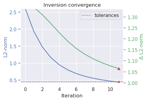
[11]:
inv.invert(
    plot_dynamic_convergence=True,
)
[12]:
_ = ptk.grid_compare(
    true_topography,
    inv.model.topography,
    grid1_name="True topography",
    grid2_name="Inverted topography",
    robust=True,
    hist=True,
    inset=False,
    title="difference",
    reverse_cpt=True,
    cmap="rain",
)
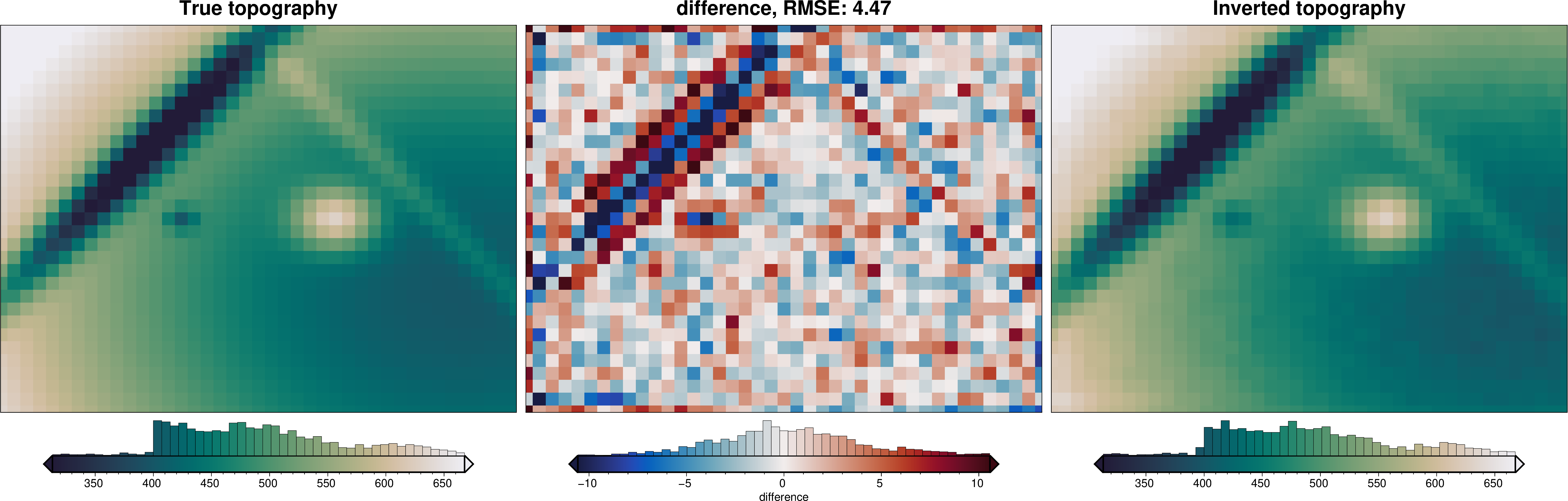
As you can see, the inversion successfully recovered the true topography. The root mean square difference between the true and recovered topography is low, but this is not too surprising since we gave the inversion the true density contrast and reference level values.