
Windowed zref and density contrast optimization#
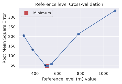
The tutorials on density contrast optimization and reference level optimization show how to use constraint points (locations of known topography) to find a single optimal density contrast and reference level (zref) for the entire inversion region. However, in many real-world scenarios these properties vary spatially; for example, the density contrast between sediment and basement may
change regionally, or the appropriate reference level may differ from one side of the region to the other.
For these situations, the method optimize_inversion_zref_density_contrast_windowed provides a windowed optimization scheme:
the region is tiled with square windows of a set width, optionally overlapping,
within each window, a standard optimization is run using the gravity data, model, and constraint points which fall inside the window (padded by an optional buffer to reduce edge effects), giving each window its own optimal parameter value(s),
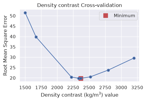
the per-window optimal values, located at the window centers, are merged (interpolated) into continuous grids of spatially variable zref and / or density contrast values,
a final inversion is run over the full region using these spatially variable grids.
This notebook demonstrates the windowed scheme for a density contrast optimization and a zref optimization.
Import packages#
[1]:
# set EPSG for plotting functions
import os

import polartoolkit as ptk
import verde as vd
import xarray as xr

import invert4geom

os.environ["POLARTOOLKIT_EPSG"] = "3857"
Create the synthetic model#
As in the other examples, we create a synthetic true topography which we hope to recover with the inversions, and a set of randomly located constraint points where we assume the true topography is known (i.e. from seismic surveys or drill sites).
[2]:
spacing = 1000
region = (0, 40000, 0, 30000)

true_topography, _, constraint_points, _ = invert4geom.load_synthetic_model(
    spacing=spacing,
    region=region,
    number_of_constraints=15,
    density_contrast=2669,
    plot_topography_diff=False,
    plot_gravity=False,
)

true_zref = true_topography.values.mean()
print(f"mean of true topography: {true_zref:.1f} m")

fig = ptk.plot_grid(
    true_topography,
    fig_height=10,
    title="True topography",
    cmap="rain",
    reverse_cpt=True,
    hist=True,
    cbar_label="elevation (m)",
    points=constraint_points,
    points_style="x.3c",
    frame=["nSWe", "xaf10000", "yaf10000"],
)
fig.show()
mean of true topography: 492.3 m
/home/mdtanker/invert4geom/.pixi/envs/default/lib/python3.13/site-packages/polartoolkit/maps.py:138: UserWarning: EPSG:3857 (Web Mercator) is not recommended, especially for high latitudes as it can cause significant distortion. Consider using a different projection.
  self.proj, self.proj_latlon, self.width, self.height = utils.set_proj(
/home/mdtanker/invert4geom/.pixi/envs/default/lib/python3.13/site-packages/polartoolkit/maps.py:1820: FutureWarning: The 'barwidth' parameter has been deprecated since v0.18.0 and will be removed in v0.20.0. Please use 'bar_width' instead.
  self.histogram(
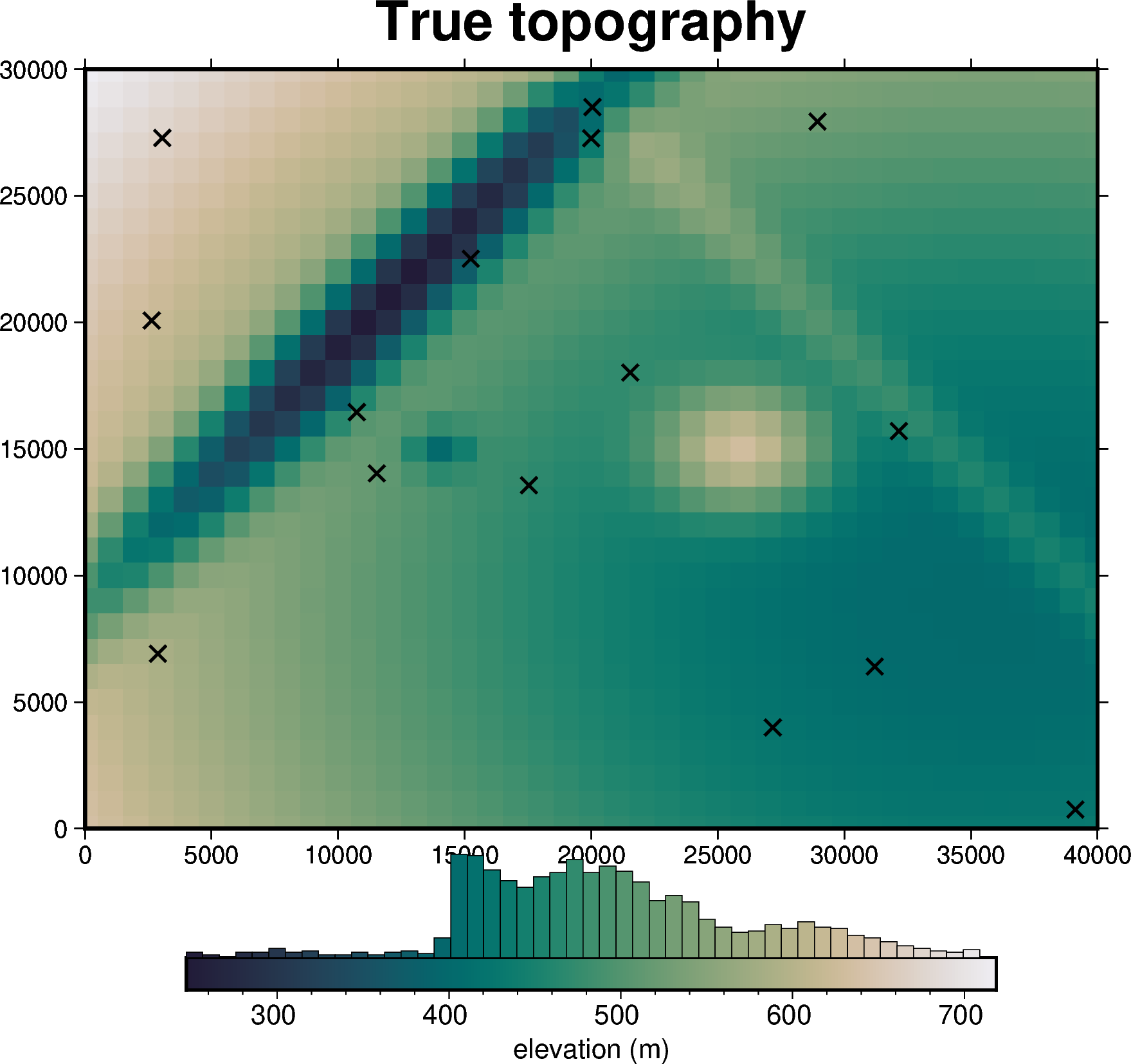
Since we will create the observed gravity and set up the starting inversion several times (once per scenario), we define two small helper functions. The first forward models the gravity of a true model and contaminates it with noise, and the second creates a flat starting model, calculates the gravity misfit and its regional / residual components, and sets up the inversion.
[3]:
def make_observed_gravity(topography, density_contrast, zref):
    """forward gravity of the true model, with 0.2 mGal of random noise"""
    true_model = invert4geom.create_model(
        zref=zref,
        density_contrast=density_contrast,
        topography=topography.to_dataset(name="upward"),
    )
    coords = vd.grid_coordinates(
        region=region,
        spacing=spacing,
        extra_coords=1000,  # survey elevation
    )
    observations = vd.make_xarray_grid(
        (coords[0], coords[1]),
        data=coords[2],
        data_names="upward",
        dims=("northing", "easting"),
    )
    data = invert4geom.create_data(observations)
    data.inv.forward_gravity(true_model, "grav")
    data["gravity_anomaly"], _ = invert4geom.contaminate(
        data.grav,
        stddev=0.2,
        percent=False,
        seed=0,
    )
    return data
Density contrast optimization#
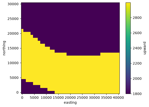
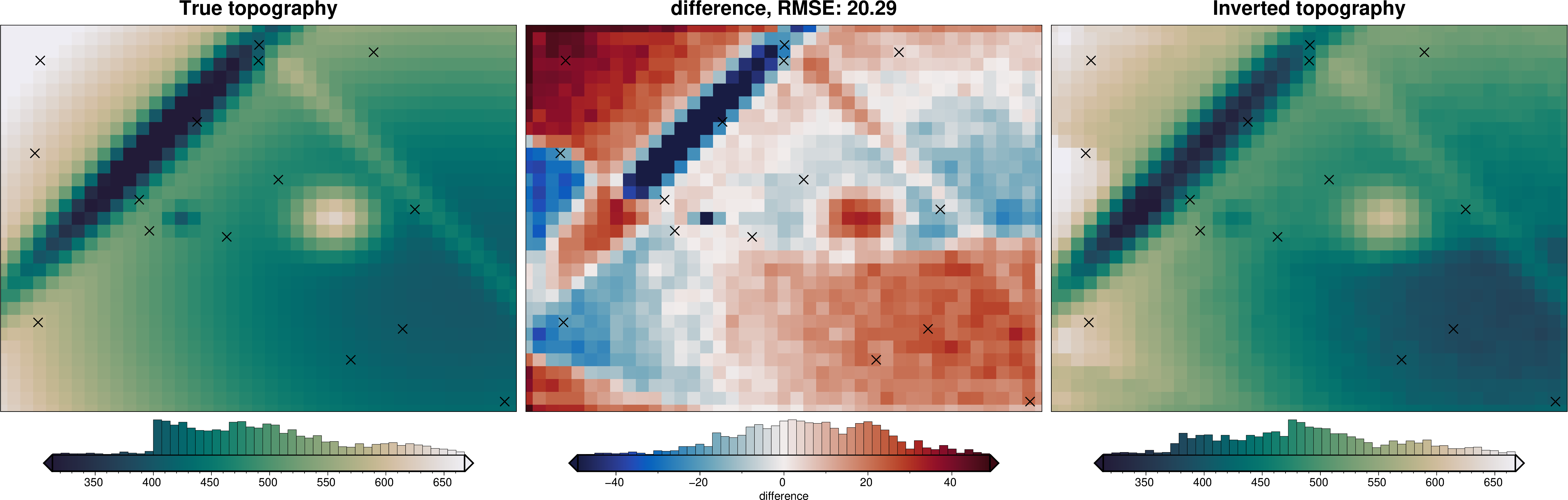
First we look at the case where the reference level is known, but the density contrast varies spatially. We create a true density distribution with two zones; a lower density (~1800 kg/m\(^3\), e.g. sediment) and a higher density (~3000 kg/m\(^3\), e.g. crystalline basement), as in the variable density notebook.
First we will perform a standard (non-windowed) density contrast optimization, then will perform a windowed version to recover a spatially-variable density contrast.
[4]:
# use some synthetic data to create a two-zone density distribution
synthetic_data = invert4geom.synthetic_topography_regional(
    spacing,
    region,
    yoffset=20,
)
density_dist = xr.where(synthetic_data > 0, 1800, 3000)

# density contrast relative to air (~1 kg/m3)
true_density_contrast = density_dist - 1

true_density_contrast.plot()
[4]:
<matplotlib.collections.QuadMesh at 0x7f58f15c96a0>
[5]:
# create the observed gravity of the true topography with the variable density
data = make_observed_gravity(true_topography, true_density_contrast, true_zref)

# create the starting model with a constant density guess and the known zref
# in this simple scenario we assume there is no regional field
starting_topography = invert4geom.create_topography(
    method="flat",
    upward=true_zref,
    region=region,
    spacing=spacing,
)
starting_model = invert4geom.create_model(
    zref=true_zref,
    density_contrast=2400,
    topography=starting_topography,
)
data.inv.forward_gravity(starting_model)
data.inv.regional_separation(method="constant", constant=0)

inv = invert4geom.Inversion(
    data,
    starting_model,
    solver_damping=0.1,
    max_iterations=30,
    l2_norm_tolerance=0.45,  # gravity error is 0.2 mGal
    delta_l2_norm_tolerance=1.005,
)
Normal density contrast optimization#
[6]:
density_optimization_obj = inv.optimize_inversion_zref_density_contrast(
    n_trials=8,
    constraints_df=constraint_points,
    density_contrast_limits=(1500, 3200),
    regional_grav_kwargs={"method": "constant", "constant": 0},
    starting_topography_kwargs={"method": "flat"},
    fname="../tmp/single_density_optimization",
    progressbar=True,
)
Inversion terminated due to max_iterations limit. Consider increasing this limit.
'forward_gravity' already a variable of `grav_ds`, but is being overwritten since calculate_starting_gravity is True
'reg' already a column of `grav_df`, but is being overwritten since calculate_regional_misfit is True
[7]:
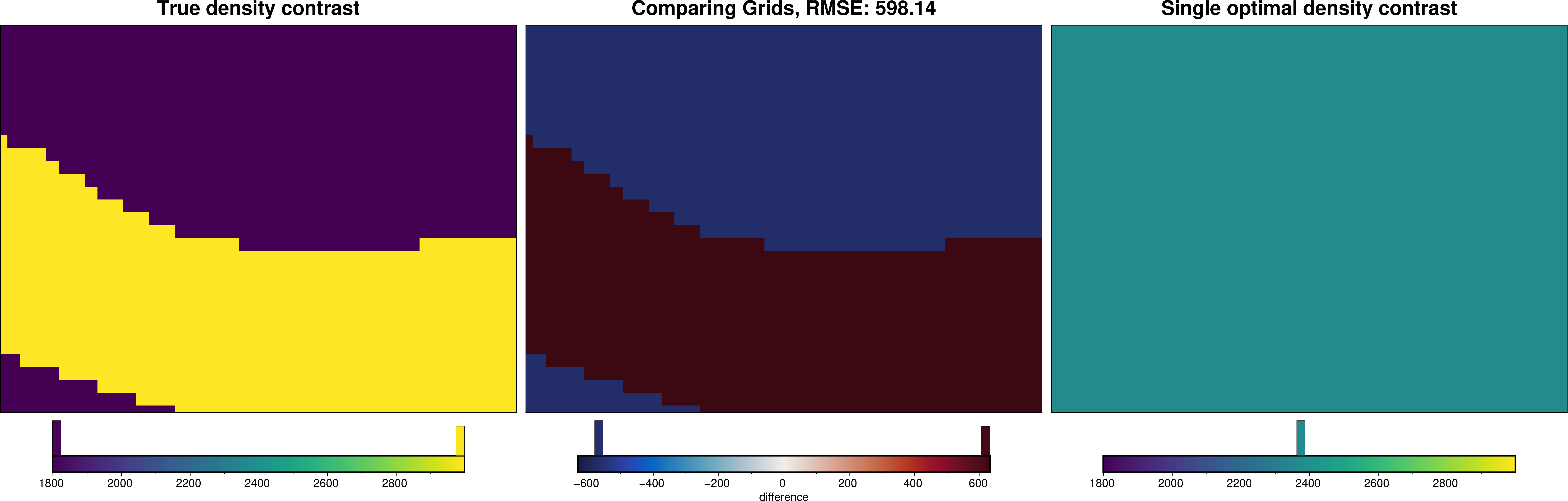
inv.used_density_contrast
[7]:
2368
[8]:
_ = ptk.grid_compare(
    true_density_contrast,
    xr.full_like(true_density_contrast, inv.used_density_contrast),
    grid1_name="True density contrast",
    grid2_name="Single optimal density contrast",
    robust=True,
    hist=True,
    inset=False,
    verbose="q",
    cmap="viridis",
)
/home/mdtanker/invert4geom/.pixi/envs/default/lib/python3.13/site-packages/polartoolkit/maps.py:138: UserWarning: EPSG:3857 (Web Mercator) is not recommended, especially for high latitudes as it can cause significant distortion. Consider using a different projection.
  self.proj, self.proj_latlon, self.width, self.height = utils.set_proj(
/home/mdtanker/invert4geom/.pixi/envs/default/lib/python3.13/site-packages/polartoolkit/maps.py:1820: FutureWarning: The 'barwidth' parameter has been deprecated since v0.18.0 and will be removed in v0.20.0. Please use 'bar_width' instead.
  self.histogram(
/home/mdtanker/invert4geom/.pixi/envs/default/lib/python3.13/site-packages/polartoolkit/maps.py:138: UserWarning: EPSG:3857 (Web Mercator) is not recommended, especially for high latitudes as it can cause significant distortion. Consider using a different projection.
  self.proj, self.proj_latlon, self.width, self.height = utils.set_proj(
/home/mdtanker/invert4geom/.pixi/envs/default/lib/python3.13/site-packages/polartoolkit/maps.py:1820: FutureWarning: The 'barwidth' parameter has been deprecated since v0.18.0 and will be removed in v0.20.0. Please use 'bar_width' instead.
  self.histogram(
/home/mdtanker/invert4geom/.pixi/envs/default/lib/python3.13/site-packages/polartoolkit/maps.py:138: UserWarning: EPSG:3857 (Web Mercator) is not recommended, especially for high latitudes as it can cause significant distortion. Consider using a different projection.
  self.proj, self.proj_latlon, self.width, self.height = utils.set_proj(
/home/mdtanker/invert4geom/.pixi/envs/default/lib/python3.13/site-packages/polartoolkit/maps.py:1820: FutureWarning: The 'barwidth' parameter has been deprecated since v0.18.0 and will be removed in v0.20.0. Please use 'bar_width' instead.
  self.histogram(
[9]:
_ = ptk.grid_compare(
    true_topography,
    inv.model.topography,
    grid1_name="True topography",
    grid2_name="Inverted topography",
    robust=True,
    hist=True,
    inset=False,
    verbose="q",
    title="difference",
    reverse_cpt=True,
    cmap="rain",
    points=constraint_points,
    points_style="x.5c",
)
/home/mdtanker/invert4geom/.pixi/envs/default/lib/python3.13/site-packages/polartoolkit/maps.py:138: UserWarning: EPSG:3857 (Web Mercator) is not recommended, especially for high latitudes as it can cause significant distortion. Consider using a different projection.
  self.proj, self.proj_latlon, self.width, self.height = utils.set_proj(
/home/mdtanker/invert4geom/.pixi/envs/default/lib/python3.13/site-packages/polartoolkit/maps.py:1820: FutureWarning: The 'barwidth' parameter has been deprecated since v0.18.0 and will be removed in v0.20.0. Please use 'bar_width' instead.
  self.histogram(
/home/mdtanker/invert4geom/.pixi/envs/default/lib/python3.13/site-packages/polartoolkit/maps.py:138: UserWarning: EPSG:3857 (Web Mercator) is not recommended, especially for high latitudes as it can cause significant distortion. Consider using a different projection.
  self.proj, self.proj_latlon, self.width, self.height = utils.set_proj(
/home/mdtanker/invert4geom/.pixi/envs/default/lib/python3.13/site-packages/polartoolkit/maps.py:1820: FutureWarning: The 'barwidth' parameter has been deprecated since v0.18.0 and will be removed in v0.20.0. Please use 'bar_width' instead.
  self.histogram(
/home/mdtanker/invert4geom/.pixi/envs/default/lib/python3.13/site-packages/polartoolkit/maps.py:138: UserWarning: EPSG:3857 (Web Mercator) is not recommended, especially for high latitudes as it can cause significant distortion. Consider using a different projection.
  self.proj, self.proj_latlon, self.width, self.height = utils.set_proj(
/home/mdtanker/invert4geom/.pixi/envs/default/lib/python3.13/site-packages/polartoolkit/maps.py:1820: FutureWarning: The 'barwidth' parameter has been deprecated since v0.18.0 and will be removed in v0.20.0. Please use 'bar_width' instead.
  self.histogram(
Windowed density contrast optimization#
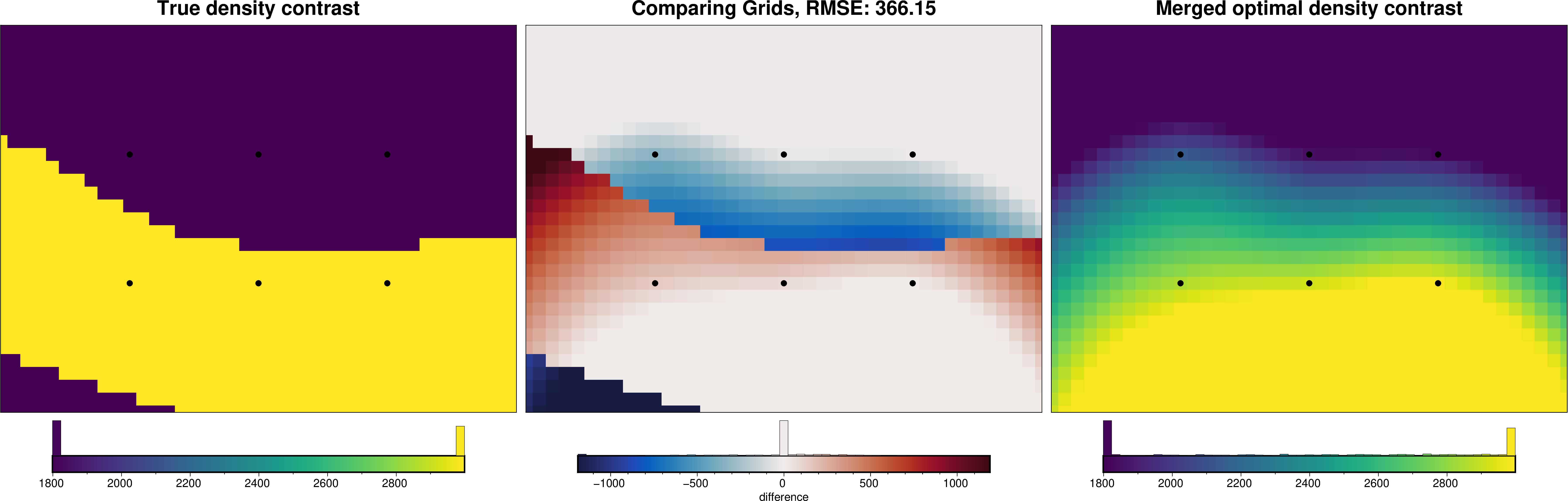
Now we run the windowed optimization. Here we choose windows of 20 km width, overlapping by 50%, which for this region gives 6 windows. Around each window we include a 5 km buffer of gravity data to reduce edge effects, although constraint points within the buffer are not used for scoring. Windows containing fewer than min_constraints constraint points are skipped.
Within each window, a standard optimization (optimize_inversion_zref_density_contrast) is run with n_trials trials. The per-window optimal values are then interpolated into a grid with a spline (merge_method="spline"), clipped to the range of the window values, and a final inversion is run with the merged spatially variable density contrast grid.
[10]:
inv.optimize_inversion_zref_density_contrast_windowed(
    n_trials=8,
    constraints_df=constraint_points,
    window_width=20000,
    window_overlap=0.5,
    window_buffer=5000,
    min_constraints=2,
    density_contrast_limits=(1500, 3200),
    regional_grav_kwargs={"method": "constant", "constant": 0},
    starting_topography_kwargs={"method": "flat"},
    fname="../tmp/windowed_density_optimization",
    progressbar=True,
)
Inversion terminated due to max_iterations limit. Consider increasing this limit.
'forward_gravity' already a variable of `grav_ds`, but is being overwritten since calculate_starting_gravity is True
'reg' already a column of `grav_df`, but is being overwritten since calculate_regional_misfit is True
Inversion terminated due to max_iterations limit. Consider increasing this limit.
'forward_gravity' already a variable of `grav_ds`, but is being overwritten since calculate_starting_gravity is True
'reg' already a column of `grav_df`, but is being overwritten since calculate_regional_misfit is True
Inversion terminated due to max_iterations limit. Consider increasing this limit.
'forward_gravity' already a variable of `grav_ds`, but is being overwritten since calculate_starting_gravity is True
'reg' already a column of `grav_df`, but is being overwritten since calculate_regional_misfit is True
Inversion terminated due to max_iterations limit. Consider increasing this limit.
'forward_gravity' already a variable of `grav_ds`, but is being overwritten since calculate_starting_gravity is True
'reg' already a column of `grav_df`, but is being overwritten since calculate_regional_misfit is True
Inversion terminated due to max_iterations limit. Consider increasing this limit.
Inversion terminated due to max_iterations limit. Consider increasing this limit.
'forward_gravity' already a variable of `grav_ds`, but is being overwritten since calculate_starting_gravity is True
'reg' already a column of `grav_df`, but is being overwritten since calculate_regional_misfit is True
Inversion terminated due to max_iterations limit. Consider increasing this limit.
Inversion terminated due to max_iterations limit. Consider increasing this limit.
'forward_gravity' already a variable of `grav_ds`, but is being overwritten since calculate_starting_gravity is True
'reg' already a column of `grav_df`, but is being overwritten since calculate_regional_misfit is True
[10]:
<invert4geom.inversion.Inversion at 0x7f57e3e54550>
The per-window results are stored in the windowed_optimization_df attribute, with each row giving the window’s region, center coordinates, optimal parameter values, score, and the number of constraint points used for scoring.
[11]:
inv.windowed_optimization_df
[11]:
| window | easting | northing | region | zref | density_contrast | score | n_constraints | |
|---|---|---|---|---|---|---|---|---|
| 0 | 0 | 10000.0 | 10000.0 | (0.0, 20000.0, 0.0, 20000.0) | None | 2853 | 3.252792 | 4 |
| 1 | 1 | 20000.0 | 10000.0 | (10000.0, 30000.0, 0.0, 20000.0) | None | 2917 | 4.992456 | 5 |
| 2 | 2 | 30000.0 | 10000.0 | (20000.0, 40000.0, 0.0, 20000.0) | None | 2988 | 7.743151 | 5 |
| 3 | 3 | 10000.0 | 20000.0 | (0.0, 20000.0, 10000.0, 30000.0) | None | 2131 | 18.761116 | 7 |
| 4 | 4 | 20000.0 | 20000.0 | (10000.0, 30000.0, 10000.0, 30000.0) | None | 1844 | 4.601566 | 8 |
| 5 | 5 | 30000.0 | 20000.0 | (20000.0, 40000.0, 10000.0, 30000.0) | None | 1814 | 1.905367 | 4 |
The merged density contrast grid is used in the final inversion and stored as the density_contrast attribute of the model. Comparing it to the true density distribution shows the windowed scheme recovers the regional trend from low densities in the north to high densities in the south.
[12]:
_ = ptk.grid_compare(
    true_density_contrast,
    inv.model.density_contrast,
    grid1_name="True density contrast",
    grid2_name="Merged optimal density contrast",
    robust=True,
    hist=True,
    inset=False,
    verbose="q",
    cmap="viridis",
    points=inv.windowed_optimization_df,
    points_style="c.2c",
)
/home/mdtanker/invert4geom/.pixi/envs/default/lib/python3.13/site-packages/polartoolkit/maps.py:138: UserWarning: EPSG:3857 (Web Mercator) is not recommended, especially for high latitudes as it can cause significant distortion. Consider using a different projection.
  self.proj, self.proj_latlon, self.width, self.height = utils.set_proj(
/home/mdtanker/invert4geom/.pixi/envs/default/lib/python3.13/site-packages/polartoolkit/maps.py:1820: FutureWarning: The 'barwidth' parameter has been deprecated since v0.18.0 and will be removed in v0.20.0. Please use 'bar_width' instead.
  self.histogram(
/home/mdtanker/invert4geom/.pixi/envs/default/lib/python3.13/site-packages/polartoolkit/maps.py:138: UserWarning: EPSG:3857 (Web Mercator) is not recommended, especially for high latitudes as it can cause significant distortion. Consider using a different projection.
  self.proj, self.proj_latlon, self.width, self.height = utils.set_proj(
/home/mdtanker/invert4geom/.pixi/envs/default/lib/python3.13/site-packages/polartoolkit/maps.py:1820: FutureWarning: The 'barwidth' parameter has been deprecated since v0.18.0 and will be removed in v0.20.0. Please use 'bar_width' instead.
  self.histogram(
/home/mdtanker/invert4geom/.pixi/envs/default/lib/python3.13/site-packages/polartoolkit/maps.py:138: UserWarning: EPSG:3857 (Web Mercator) is not recommended, especially for high latitudes as it can cause significant distortion. Consider using a different projection.
  self.proj, self.proj_latlon, self.width, self.height = utils.set_proj(
/home/mdtanker/invert4geom/.pixi/envs/default/lib/python3.13/site-packages/polartoolkit/maps.py:1820: FutureWarning: The 'barwidth' parameter has been deprecated since v0.18.0 and will be removed in v0.20.0. Please use 'bar_width' instead.
  self.histogram(
[13]:
_ = ptk.grid_compare(
    true_topography,
    inv.model.topography,
    grid1_name="True topography",
    grid2_name="Inverted topography",
    robust=True,
    hist=True,
    inset=False,
    verbose="q",
    title="difference",
    reverse_cpt=True,
    cmap="rain",
    points=constraint_points,
    points_style="x.5c",
)
/home/mdtanker/invert4geom/.pixi/envs/default/lib/python3.13/site-packages/polartoolkit/maps.py:138: UserWarning: EPSG:3857 (Web Mercator) is not recommended, especially for high latitudes as it can cause significant distortion. Consider using a different projection.
  self.proj, self.proj_latlon, self.width, self.height = utils.set_proj(
/home/mdtanker/invert4geom/.pixi/envs/default/lib/python3.13/site-packages/polartoolkit/maps.py:1820: FutureWarning: The 'barwidth' parameter has been deprecated since v0.18.0 and will be removed in v0.20.0. Please use 'bar_width' instead.
  self.histogram(
/home/mdtanker/invert4geom/.pixi/envs/default/lib/python3.13/site-packages/polartoolkit/maps.py:138: UserWarning: EPSG:3857 (Web Mercator) is not recommended, especially for high latitudes as it can cause significant distortion. Consider using a different projection.
  self.proj, self.proj_latlon, self.width, self.height = utils.set_proj(
/home/mdtanker/invert4geom/.pixi/envs/default/lib/python3.13/site-packages/polartoolkit/maps.py:1820: FutureWarning: The 'barwidth' parameter has been deprecated since v0.18.0 and will be removed in v0.20.0. Please use 'bar_width' instead.
  self.histogram(
/home/mdtanker/invert4geom/.pixi/envs/default/lib/python3.13/site-packages/polartoolkit/maps.py:138: UserWarning: EPSG:3857 (Web Mercator) is not recommended, especially for high latitudes as it can cause significant distortion. Consider using a different projection.
  self.proj, self.proj_latlon, self.width, self.height = utils.set_proj(
/home/mdtanker/invert4geom/.pixi/envs/default/lib/python3.13/site-packages/polartoolkit/maps.py:1820: FutureWarning: The 'barwidth' parameter has been deprecated since v0.18.0 and will be removed in v0.20.0. Please use 'bar_width' instead.
  self.histogram(
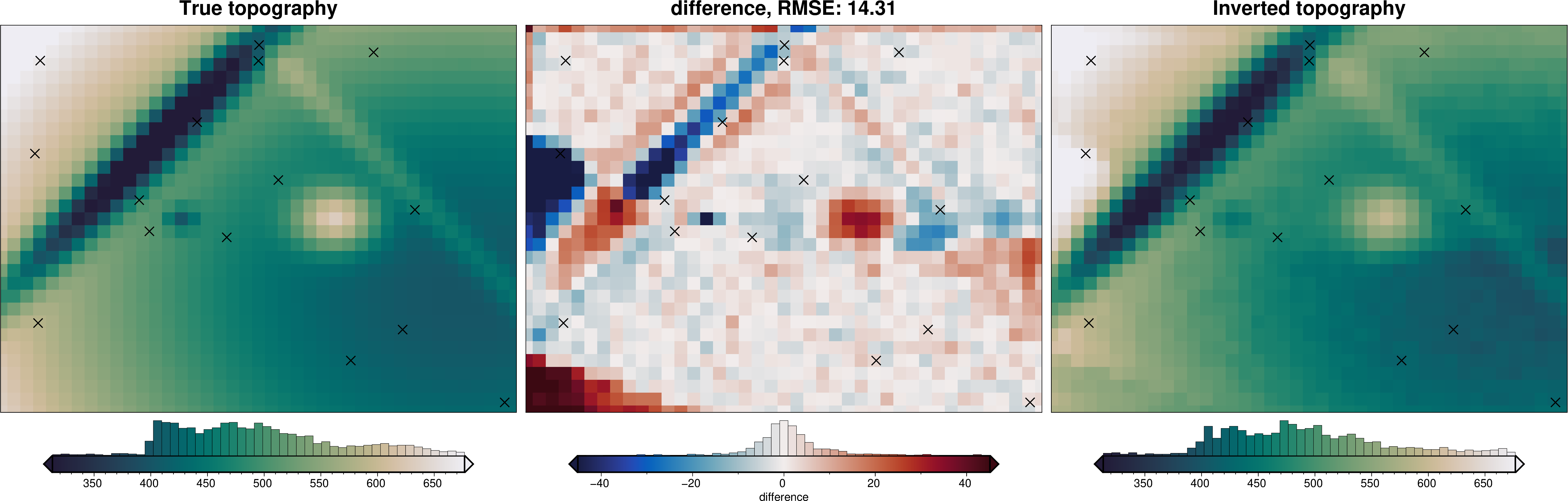
From the above figure, with our spatially variable estimated density contrast, we achieved an inversion with an RMSE of ~14 m. When we used a single density contrast value (non-spatially variable), the RMSE was ~20 m.
Reference level optimization#
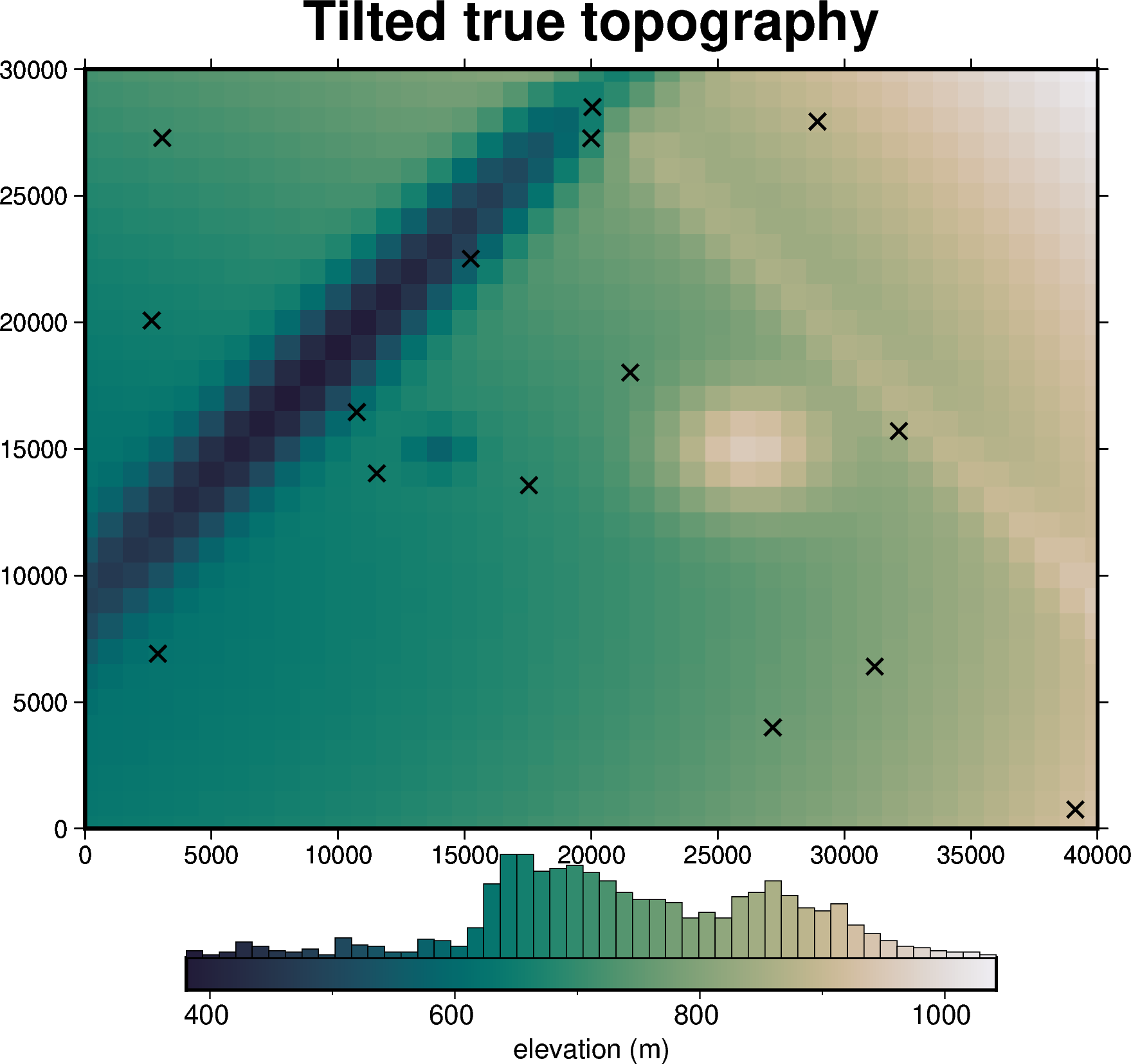
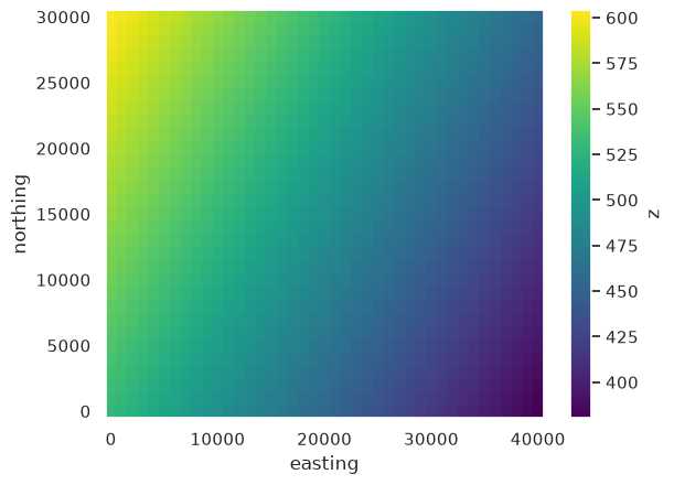
Next we look at the case where the density contrast is known, but the appropriate reference level varies spatially. To simulate this, we tilt the true topography with a linear ramp of 500 m across the region, and define a true reference level (used to calculate the observed gravity) as a 1st order trend fit to this tilted topography.
[14]:
# tilt the true topography with a west-east ramp of 500 m
ramp = 500 * (
    (true_topography.easting - region[0]) / (region[1] - region[0])
).broadcast_like(true_topography)
tilted_topography = true_topography + ramp

# re-sample the constraint points on the tilted topography
tilted_constraints = constraint_points.drop(columns="upward")
tilted_constraints = invert4geom.sample_grids(
    tilted_constraints,
    tilted_topography,
    sampled_name="upward",
)

fig = ptk.plot_grid(
    tilted_topography,
    fig_height=10,
    title="Tilted true topography",
    cmap="rain",
    reverse_cpt=True,
    hist=True,
    cbar_label="elevation (m)",
    points=tilted_constraints,
    points_style="x.3c",
    frame=["nSWe", "xaf10000", "yaf10000"],
)
fig.show()
/home/mdtanker/invert4geom/.pixi/envs/default/lib/python3.13/site-packages/polartoolkit/maps.py:138: UserWarning: EPSG:3857 (Web Mercator) is not recommended, especially for high latitudes as it can cause significant distortion. Consider using a different projection.
  self.proj, self.proj_latlon, self.width, self.height = utils.set_proj(
/home/mdtanker/invert4geom/.pixi/envs/default/lib/python3.13/site-packages/polartoolkit/maps.py:1820: FutureWarning: The 'barwidth' parameter has been deprecated since v0.18.0 and will be removed in v0.20.0. Please use 'bar_width' instead.
  self.histogram(
[15]:
# make the true zref a 1st order trend fit the the true topography

df = vd.grid_to_table(true_topography)

vdtrend = vd.Trend(degree=1).fit(
    (df.easting, df.northing),
    df.upward,
)

true_zref = vdtrend.grid(
    coordinates=(tilted_topography.easting, tilted_topography.northing),
    data_names=["z"],
    dims=("northing", "easting"),
).z

true_zref.plot()
[15]:
<matplotlib.collections.QuadMesh at 0x7f57e3fc8e10>
[16]:
# the true density contrast is a constant 2669 kg/m3 in this scenario
data = make_observed_gravity(tilted_topography, 2669, true_zref)

# create the starting model with the known density and a first guess for zref,
starting_topography = invert4geom.create_topography(
    method="flat",
    upward=true_zref.values.mean(),
    region=region,
    spacing=spacing,
)
starting_model = invert4geom.create_model(
    zref=true_zref,
    density_contrast=2669,
    topography=starting_topography,
)
data.inv.forward_gravity(starting_model)
data.inv.regional_separation(method="constant", constant=0)

inv = invert4geom.Inversion(
    data,
    starting_model,
    solver_damping=0.1,
    max_iterations=30,
    l2_norm_tolerance=0.45,  # gravity error is 0.2 mGal
    delta_l2_norm_tolerance=1.005,
)
Normal reference level optimization#
[17]:
zref_optimization_obj = inv.optimize_inversion_zref_density_contrast(
    n_trials=8,
    constraints_df=tilted_constraints,
    zref_limits=(300, 1100),
    regional_grav_kwargs={"method": "constant", "constant": 0},
    starting_topography_kwargs={"method": "flat"},
    fname="../tmp/single_zref_optimization",
    progressbar=True,
)
'forward_gravity' already a variable of `grav_ds`, but is being overwritten since calculate_starting_gravity is True
'reg' already a column of `grav_df`, but is being overwritten since calculate_regional_misfit is True
[18]:
_ = ptk.grid_compare(
    tilted_topography,
    inv.model.topography,
    grid1_name="True (tilted) topography",
    grid2_name="Inverted topography",
    robust=True,
    hist=True,
    inset=False,
    verbose="q",
    title="difference",
    reverse_cpt=True,
    cmap="rain",
    points=tilted_constraints,
    points_style="x.3c",
)
/home/mdtanker/invert4geom/.pixi/envs/default/lib/python3.13/site-packages/polartoolkit/maps.py:138: UserWarning: EPSG:3857 (Web Mercator) is not recommended, especially for high latitudes as it can cause significant distortion. Consider using a different projection.
  self.proj, self.proj_latlon, self.width, self.height = utils.set_proj(
/home/mdtanker/invert4geom/.pixi/envs/default/lib/python3.13/site-packages/polartoolkit/maps.py:1820: FutureWarning: The 'barwidth' parameter has been deprecated since v0.18.0 and will be removed in v0.20.0. Please use 'bar_width' instead.
  self.histogram(
/home/mdtanker/invert4geom/.pixi/envs/default/lib/python3.13/site-packages/polartoolkit/maps.py:138: UserWarning: EPSG:3857 (Web Mercator) is not recommended, especially for high latitudes as it can cause significant distortion. Consider using a different projection.
  self.proj, self.proj_latlon, self.width, self.height = utils.set_proj(
/home/mdtanker/invert4geom/.pixi/envs/default/lib/python3.13/site-packages/polartoolkit/maps.py:1820: FutureWarning: The 'barwidth' parameter has been deprecated since v0.18.0 and will be removed in v0.20.0. Please use 'bar_width' instead.
  self.histogram(
/home/mdtanker/invert4geom/.pixi/envs/default/lib/python3.13/site-packages/polartoolkit/maps.py:138: UserWarning: EPSG:3857 (Web Mercator) is not recommended, especially for high latitudes as it can cause significant distortion. Consider using a different projection.
  self.proj, self.proj_latlon, self.width, self.height = utils.set_proj(
/home/mdtanker/invert4geom/.pixi/envs/default/lib/python3.13/site-packages/polartoolkit/maps.py:1820: FutureWarning: The 'barwidth' parameter has been deprecated since v0.18.0 and will be removed in v0.20.0. Please use 'bar_width' instead.
  self.histogram(
Windowed zref optimization#
[19]:
inv.optimize_inversion_zref_density_contrast_windowed(
    n_trials=8,
    constraints_df=tilted_constraints,
    window_width=10000,
    window_overlap=0.5,
    window_buffer=2000,
    min_constraints=2,
    zref_limits=(300, 1100),
    regional_grav_kwargs={"method": "constant", "constant": 0},
    starting_topography_kwargs={"method": "flat"},
    fname="../tmp/windowed_zref_optimization",
    progressbar=True,
)
skipping window 0; 1 constraint points inside window but 2 required
skipping window 1; 0 constraint points inside window but 2 required
skipping window 2; 0 constraint points inside window but 2 required
skipping window 3; 0 constraint points inside window but 2 required
skipping window 4; 1 constraint points inside window but 2 required
'forward_gravity' already a variable of `grav_ds`, but is being overwritten since calculate_starting_gravity is True
'reg' already a column of `grav_df`, but is being overwritten since calculate_regional_misfit is True
'forward_gravity' already a variable of `grav_ds`, but is being overwritten since calculate_starting_gravity is True
'reg' already a column of `grav_df`, but is being overwritten since calculate_regional_misfit is True
skipping window 7; 1 constraint points inside window but 2 required
skipping window 8; 1 constraint points inside window but 2 required
Inversion terminated due to max_iterations limit. Consider increasing this limit.
'forward_gravity' already a variable of `grav_ds`, but is being overwritten since calculate_starting_gravity is True
'reg' already a column of `grav_df`, but is being overwritten since calculate_regional_misfit is True
skipping window 10; 1 constraint points inside window but 2 required
skipping window 11; 0 constraint points inside window but 2 required
skipping window 12; 1 constraint points inside window but 2 required
skipping window 13; 1 constraint points inside window but 2 required
skipping window 14; 0 constraint points inside window but 2 required
Inversion terminated due to max_iterations limit. Consider increasing this limit.
'forward_gravity' already a variable of `grav_ds`, but is being overwritten since calculate_starting_gravity is True
'reg' already a column of `grav_df`, but is being overwritten since calculate_regional_misfit is True
Inversion terminated due to max_iterations limit. Consider increasing this limit.
'forward_gravity' already a variable of `grav_ds`, but is being overwritten since calculate_starting_gravity is True
'reg' already a column of `grav_df`, but is being overwritten since calculate_regional_misfit is True
'forward_gravity' already a variable of `grav_ds`, but is being overwritten since calculate_starting_gravity is True
'reg' already a column of `grav_df`, but is being overwritten since calculate_regional_misfit is True
skipping window 18; 1 constraint points inside window but 2 required
skipping window 19; 1 constraint points inside window but 2 required
skipping window 20; 1 constraint points inside window but 2 required
skipping window 21; 1 constraint points inside window but 2 required
skipping window 22; 1 constraint points inside window but 2 required
Inversion terminated due to max_iterations limit. Consider increasing this limit.
'forward_gravity' already a variable of `grav_ds`, but is being overwritten since calculate_starting_gravity is True
'reg' already a column of `grav_df`, but is being overwritten since calculate_regional_misfit is True
Inversion terminated due to max_iterations limit. Consider increasing this limit.
'forward_gravity' already a variable of `grav_ds`, but is being overwritten since calculate_starting_gravity is True
'reg' already a column of `grav_df`, but is being overwritten since calculate_regional_misfit is True
skipping window 25; 1 constraint points inside window but 2 required
skipping window 26; 1 constraint points inside window but 2 required
skipping window 27; 1 constraint points inside window but 2 required
Inversion terminated due to max_iterations limit. Consider increasing this limit.
'forward_gravity' already a variable of `grav_ds`, but is being overwritten since calculate_starting_gravity is True
'reg' already a column of `grav_df`, but is being overwritten since calculate_regional_misfit is True
skipping window 29; 0 constraint points inside window but 2 required
Inversion terminated due to max_iterations limit. Consider increasing this limit.
'forward_gravity' already a variable of `grav_ds`, but is being overwritten since calculate_starting_gravity is True
'reg' already a column of `grav_df`, but is being overwritten since calculate_regional_misfit is True
Inversion terminated due to max_iterations limit. Consider increasing this limit.
'forward_gravity' already a variable of `grav_ds`, but is being overwritten since calculate_starting_gravity is True
'reg' already a column of `grav_df`, but is being overwritten since calculate_regional_misfit is True
'forward_gravity' already a variable of `grav_ds`, but is being overwritten since calculate_starting_gravity is True
'reg' already a column of `grav_df`, but is being overwritten since calculate_regional_misfit is True
skipping window 33; 1 constraint points inside window but 2 required
skipping window 34; 0 constraint points inside window but 2 required
[19]:
<invert4geom.inversion.Inversion at 0x7f58f15339d0>
[20]:
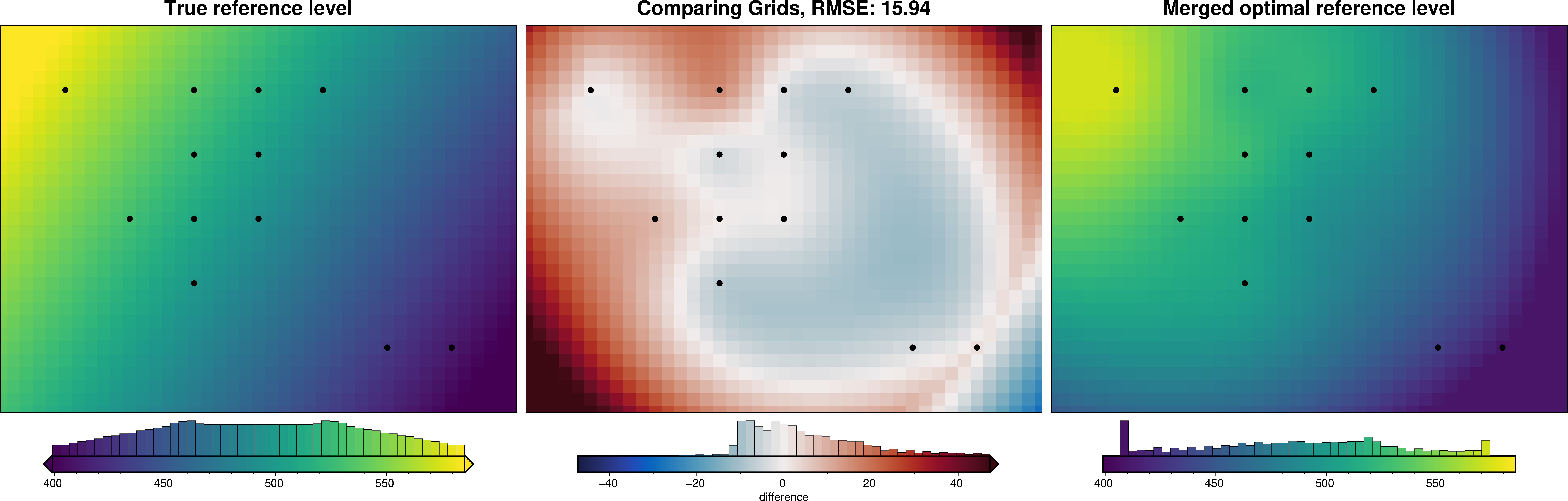
inv.windowed_optimization_df
[20]:
| window | easting | northing | region | zref | density_contrast | score | n_constraints | |
|---|---|---|---|---|---|---|---|---|
| 0 | 5 | 30000.0 | 5000.0 | (25000.0, 35000.0, 0.0, 10000.0) | 433.916769 | None | 6.546223 | 2 |
| 1 | 6 | 35000.0 | 5000.0 | (30000.0, 40000.0, 0.0, 10000.0) | 409.190240 | None | 15.433747 | 2 |
| 2 | 9 | 15000.0 | 10000.0 | (10000.0, 20000.0, 5000.0, 15000.0) | 505.892247 | None | 14.934851 | 2 |
| 3 | 15 | 10000.0 | 15000.0 | (5000.0, 15000.0, 10000.0, 20000.0) | 520.731824 | None | 2.907364 | 2 |
| 4 | 16 | 15000.0 | 15000.0 | (10000.0, 20000.0, 10000.0, 20000.0) | 510.488718 | None | 14.520618 | 3 |
| 5 | 17 | 20000.0 | 15000.0 | (15000.0, 25000.0, 10000.0, 20000.0) | 493.105210 | None | 4.590245 | 2 |
| 6 | 23 | 15000.0 | 20000.0 | (10000.0, 20000.0, 15000.0, 25000.0) | 527.077170 | None | 2.991530 | 2 |
| 7 | 24 | 20000.0 | 20000.0 | (15000.0, 25000.0, 15000.0, 25000.0) | 505.845613 | None | 19.063215 | 2 |
| 8 | 28 | 5000.0 | 25000.0 | (0.0, 10000.0, 20000.0, 30000.0) | 573.132797 | None | 5.688308 | 2 |
| 9 | 30 | 15000.0 | 25000.0 | (10000.0, 20000.0, 20000.0, 30000.0) | 520.299866 | None | 6.478344 | 2 |
| 10 | 31 | 20000.0 | 25000.0 | (15000.0, 25000.0, 20000.0, 30000.0) | 520.393824 | None | 2.933917 | 3 |
| 11 | 32 | 25000.0 | 25000.0 | (20000.0, 30000.0, 20000.0, 30000.0) | 504.724184 | None | 20.272145 | 2 |
[21]:
_ = ptk.grid_compare(
    true_zref,
    inv.model.zref,
    grid1_name="True reference level",
    grid2_name="Merged optimal reference level",
    robust=True,
    hist=True,
    inset=False,
    verbose="q",
    cmap="viridis",
    points=inv.windowed_optimization_df,
    points_style="c.2c",
)
/home/mdtanker/invert4geom/.pixi/envs/default/lib/python3.13/site-packages/polartoolkit/maps.py:138: UserWarning: EPSG:3857 (Web Mercator) is not recommended, especially for high latitudes as it can cause significant distortion. Consider using a different projection.
  self.proj, self.proj_latlon, self.width, self.height = utils.set_proj(
/home/mdtanker/invert4geom/.pixi/envs/default/lib/python3.13/site-packages/polartoolkit/maps.py:1820: FutureWarning: The 'barwidth' parameter has been deprecated since v0.18.0 and will be removed in v0.20.0. Please use 'bar_width' instead.
  self.histogram(
/home/mdtanker/invert4geom/.pixi/envs/default/lib/python3.13/site-packages/polartoolkit/maps.py:138: UserWarning: EPSG:3857 (Web Mercator) is not recommended, especially for high latitudes as it can cause significant distortion. Consider using a different projection.
  self.proj, self.proj_latlon, self.width, self.height = utils.set_proj(
/home/mdtanker/invert4geom/.pixi/envs/default/lib/python3.13/site-packages/polartoolkit/maps.py:1820: FutureWarning: The 'barwidth' parameter has been deprecated since v0.18.0 and will be removed in v0.20.0. Please use 'bar_width' instead.
  self.histogram(
/home/mdtanker/invert4geom/.pixi/envs/default/lib/python3.13/site-packages/polartoolkit/maps.py:138: UserWarning: EPSG:3857 (Web Mercator) is not recommended, especially for high latitudes as it can cause significant distortion. Consider using a different projection.
  self.proj, self.proj_latlon, self.width, self.height = utils.set_proj(
/home/mdtanker/invert4geom/.pixi/envs/default/lib/python3.13/site-packages/polartoolkit/maps.py:1820: FutureWarning: The 'barwidth' parameter has been deprecated since v0.18.0 and will be removed in v0.20.0. Please use 'bar_width' instead.
  self.histogram(
[22]:
_ = ptk.grid_compare(
    tilted_topography,
    inv.model.topography,
    grid1_name="True (tilted) topography",
    grid2_name="Inverted topography",
    robust=True,
    hist=True,
    inset=False,
    verbose="q",
    title="difference",
    reverse_cpt=True,
    cmap="rain",
    points=tilted_constraints,
    points_style="x.3c",
)
/home/mdtanker/invert4geom/.pixi/envs/default/lib/python3.13/site-packages/polartoolkit/maps.py:138: UserWarning: EPSG:3857 (Web Mercator) is not recommended, especially for high latitudes as it can cause significant distortion. Consider using a different projection.
  self.proj, self.proj_latlon, self.width, self.height = utils.set_proj(
/home/mdtanker/invert4geom/.pixi/envs/default/lib/python3.13/site-packages/polartoolkit/maps.py:1820: FutureWarning: The 'barwidth' parameter has been deprecated since v0.18.0 and will be removed in v0.20.0. Please use 'bar_width' instead.
  self.histogram(
/home/mdtanker/invert4geom/.pixi/envs/default/lib/python3.13/site-packages/polartoolkit/maps.py:138: UserWarning: EPSG:3857 (Web Mercator) is not recommended, especially for high latitudes as it can cause significant distortion. Consider using a different projection.
  self.proj, self.proj_latlon, self.width, self.height = utils.set_proj(
/home/mdtanker/invert4geom/.pixi/envs/default/lib/python3.13/site-packages/polartoolkit/maps.py:1820: FutureWarning: The 'barwidth' parameter has been deprecated since v0.18.0 and will be removed in v0.20.0. Please use 'bar_width' instead.
  self.histogram(
/home/mdtanker/invert4geom/.pixi/envs/default/lib/python3.13/site-packages/polartoolkit/maps.py:138: UserWarning: EPSG:3857 (Web Mercator) is not recommended, especially for high latitudes as it can cause significant distortion. Consider using a different projection.
  self.proj, self.proj_latlon, self.width, self.height = utils.set_proj(
/home/mdtanker/invert4geom/.pixi/envs/default/lib/python3.13/site-packages/polartoolkit/maps.py:1820: FutureWarning: The 'barwidth' parameter has been deprecated since v0.18.0 and will be removed in v0.20.0. Please use 'bar_width' instead.
  self.histogram(
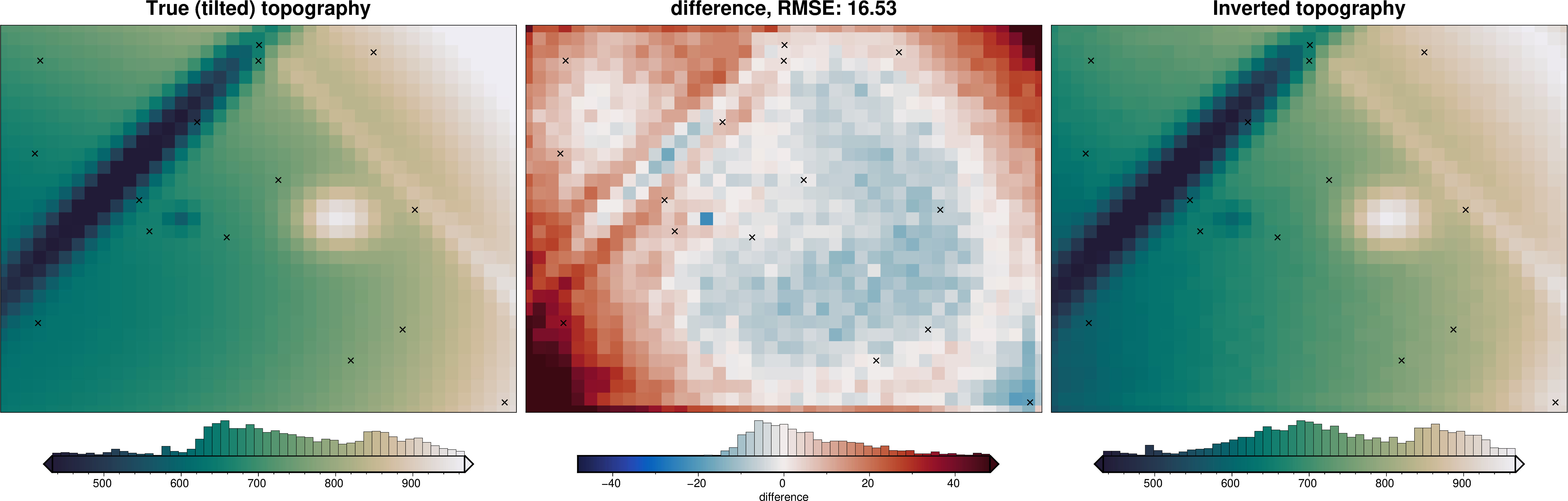
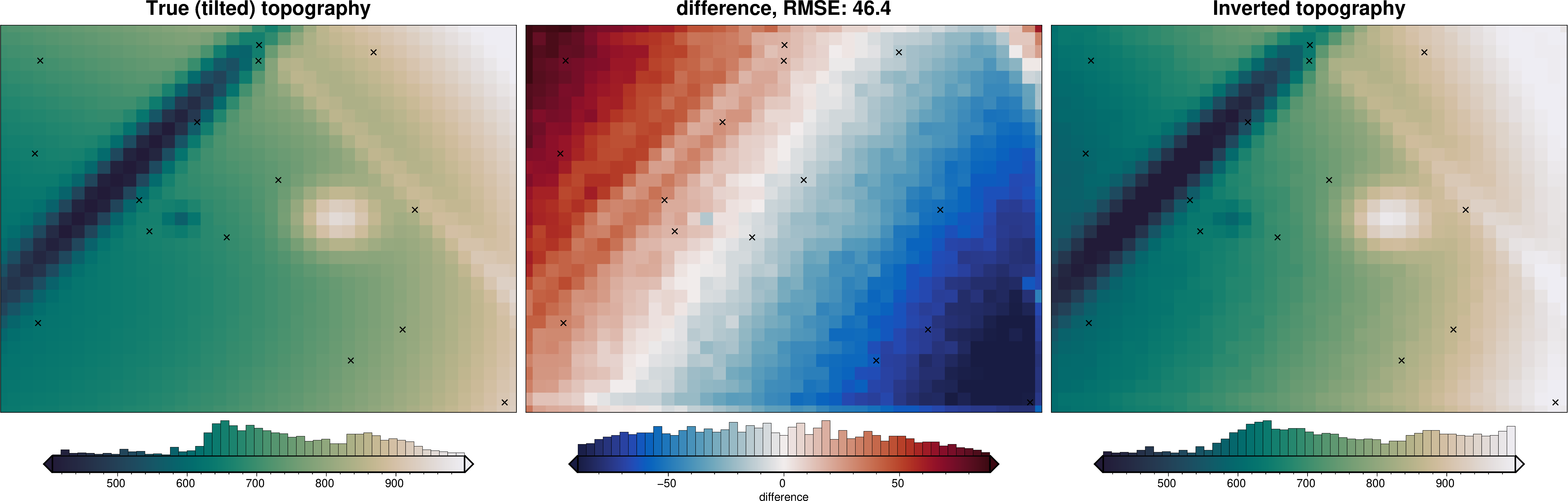
From the above figure, with our spatially variable estimated reference level, we achieved an inversion with an RMSE of ~17 m. When we used a single reference level (non-spatially variable), the RMSE was ~46 m.
Practical considerations#
Some tips for using the windowed scheme on real data:
Window width: windows need to be small enough to capture the spatial variability you expect, but large enough that each window contains enough gravity data and constraint points for a meaningful optimization. The number of constraints is usually the limiting factor.
Overlap: overlapping windows (e.g.
window_overlap=0.5) give more window centers and smoother merged grids, at the cost of more optimizations.Buffer:
window_bufferincludes extra gravity data around each window to reduce edge effects in the per-window inversions, without using the extra constraint points for scoring. It must be a multiple of the grid spacing.Skipped windows: windows with fewer than
min_constraintsconstraint points, or where the optimization fails, are skipped with a logged warning. Checkwindowed_optimization_dfto see which windows contributed.Merging:
merge_method="spline"(optionally withmerge_damping) gives smooth grids, whilemerge_method="nearest"gives a piecewise-constant mosaic. Merged values are always clipped to the range of the per-window optimal values.Cost: the total number of inversions is roughly
number of windows x (n_trials + 1), plus the final full-region inversion, so start with few windows and trials.